5:51 PM Tuesday, June 6, 2023
The pattern continues to be stuck with no big changes occurring anytime soon.
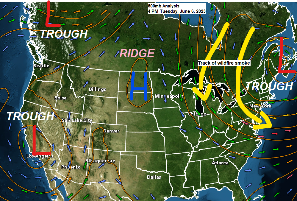
Basically, we’re seeing two troughs, one over the northeast U.S., the other over the southwest U.S, with an upper-level ridge in between, and that ridge has had a tendency to shift east and west a bit over the last few weeks.
Computer models show little to no change to this pattern, and the net result from this for northeast Minnesota and northwest Wisconsin is for very little rainfall over at least the next 5 days and it’ll likely end up being even longer than that.
Highs in the 70s away from Lake Superior Wednesday and Thursday with 70s and lower 80s area-wide Friday as will get a brief wind shift near Lake Superior out ahead of the next cold front which will shift winds back to the NE again once that front moves through, but at least will get one day of warmth near Lake Superior this week, and that comes on Friday.
One piece of good news out of this pattern is the threat for air quality issues due to wildfire smoke is on the low side across the Northland over the next few days as northerly winds aloft help keep most of the impactful smoke east of our area, but wow there is a lot of fire activity ongoing in Quebec and also in eastern Ontario, or just to the east of Lake Superior and north of Lake Huron per satellite imagery.
Visible satellite image from Tuesday afternoon.

Looking back at daily precipitation totals for Duluth one can see how the pattern changed from getting roughly 2 or 3 precipitation events a week to 1 or less starting about May 11th, so we’re closing in on a month of this new pattern which has featured very little precipitation in Duluth.

There could be a few showers or sprinkles in the Twin Ports Friday-early Saturday as a cold front moves through, but overall, there isn’t much rain in the forecast at least through Sunday.

Water vapor loop from today showing the amplified/blocky weather pattern which continues to be in place.

This blocky pattern this spring has also led to minimal severe weather across the Northland with the NWS in Duluth only issuing 1 warning in their forecast area so far this spring, this compares to 52 warnings which were issued by the NWS in Duluth by this time last spring.
As you can see on the chart below there’s been plenty of years which have had a very slow start to the severe weather season in the Northland, so this really isn’t anything too unusual, but there are no strong signals showing up in long-range model guidance which would indicate an uptick in severe weather in the Northland at least for the next week or so.

Tim
Leave a Reply