6:02 PM Monday, June 5, 2023
*No change in the pattern this week.
*Scattered showers in northern Minnesota this evening.
*Wildfire smoke lingers over parts of the Northland tonight with improving conditions expected from east to west on Tuesday.
*Highs in the Northland (away from Lake Superior) ranging from the 70s to lower 80s Tuesday through Thursday with 50s closer to Lake Superior as persistent NE winds continue the next few days.
*Cold front moves through on Friday which is when our next chance for rain is, but those chances look pretty low at the moment.
Scattered showers and isolated thunderstorms over northern Minnesota late this afternoon will continue to move very slowly toward the south/southwest this evening before ending later tonight. Heavy downpours are likely where these storms occur this evening.

Looks like will be staying dry in Duluth at least through Friday morning.
Note — May 18th was the last time the Duluth Airport picked up at least a quarter inch of rain.
Rain chances are highest this evening in northern Minnesota with generally dry conditions expected across the Northland Tuesday through Thursday.

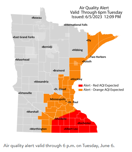
Source: Minnesota Pollution Control Agency
Air Quality Alert is in effect until 6 PM Tuesday for east central and southeast Minnesota and also for northeast Minnesota including the North Shore.
Air Quality Alert is in effect until Midnight tonight for all of northwest Wisconsin.
A band of smoke from wildfires in Quebec will continue to impact the aforementioned areas through Tuesday.
For northeast and east central Minnesota — Smoke concentrations will be greatest along Lake Superior as well as the St. Louis River Valley in the Duluth area.
Some of the worst air quality in Minnesota and Wisconsin is found right at the head of Lake Superior including the Duluth area late this afternoon, extending east-southeast across portions of northwest into west central Wisconsin where AQI has reached the red category late Monday afternoon.

First it was western Canada which had widespread fire activity last month, and now so far this month it’s been eastern Canada which has been very active in terms of fire activity.
Smoke originating from fires in Quebec continues to push toward the west-southwest due to east and northeast winds today.
Note — Orange outlined areas on the image below represent a rough estimate of where there are active fires this afternoon based on satellite imagery.

Here’s a loop of the image above from Monday, June 5, 2023 (loop time ends 4:40 PM CT)

Some parts of the Northland saw some rain today.
Radar rainfall estimates through 12 PM Monday, June 5, 2023.

24-Hour Rainfall Reports ending 5 PM Monday, June 5, 2023
Source: MesoWest; NWS Duluth, MN
Northome, MN: 0.36″
Superior Airport: 0.29″
Hermantown, MN: 0.16″
Saginaw, MN: 0.14″
Esko, MN: 0.12″
Moose Lake, MN: 0.09″
Walker, MN: 0.07″
Webb Lake, WI: 0.07″
Duluth Airport: 0.04″
Brainerd, MN: 0.04″
Cloquet, MN: 0.04″
McGregor, MN: 0.03″
Solon Springs, WI: 0.03″
Minong, WI: 0.03″
Cass Lake, MN: 0.02″
Hinckley, MN: 0.02″
Duluth Sky Harbor Airport: 0.01″
Tim
Leave a Reply