6:10 PM Wednesday, June 28, 2023
Rain and a few thunderstorms will come to an end in the Northland tonight, but fog will be an issue, with dense fog possible in spots. Fog that forms should burn off around or a little past sunrise on Thursday.
Warmer temperatures return on Thursday with highs in the 70s to lower 80s. A cold front approaching from the NW combined with some lingering moisture and instability will likely cause some showers and thunderstorms to develop in the Northland on Thursday (especially during the afternoon/early evening)
Although Friday through Sunday looks dry for the most part, there still could be a few isolated showers or thunderstorms on any one of those days, but the majority of us in the Northland should be dry.
It took less than a week for the rainfall anomaly for June 2023 to go from >3″ below normal to only -0.06″ below normal (as of 4 PM on the 28th) at the Duluth Airport.
Nearly 4 inches of rain has fallen at the Duluth Airport in just the last 6 days (3.95″ of rain thru 4 PM on the 28th) The average rainfall total from June 23-28 is 1.00″.
Percent of normal rainfall at the Duluth Airport from June 23-28 — 395% of normal!
Other parts of the Northland are still running -1 to -2 inches below normal in rainfall this month, here’s a look at updated rainfall anomalies for June 2023 (thru 4 PM on the 28th)
Ashland, WI: -2.78″ below normal
Hibbing, MN: -2.26″ below normal
Brainerd, MN: -1.37″ below normal
International Falls, MN: -0.90″ below normal
Duluth, MN: -0.06″ below normal
24-Hour Rainfall Reports from June 27-28, 2023
Ending on the 28th at 4 PM
Source: MesoWest
Hermantown, MN: 2.53″
Duluth Airport: 2.01″
Saginaw, MN: 1.54″
French River, MN: 1.47″
Winton, MN: 1.27″
Two Harbors, MN: 1.04″
Superior Airport: 0.86″
Duluth Sky Harbor Airport: 0.85″
Shell Lake, WI: 0.83″
Esko, MN: 0.74″
Glidden, WI: 0.68″
Aitkin, MN: 0.58″
Hill City, MN: 0.57″
Ely, MN: 0.57″
McGregor, MN: 0.55″
Chisholm-Hibbing Airport: 0.54″
Eveleth, MN: 0.53″
Clam Lake, WI: 0.49″
Moose Lake, MN: 0.43″
Hayward, WI: 0.42″
Littlefork, MN: 0.41″
Brainerd, MN: 0.41″
Minong, WI: 0.41″
Longville, MN: 0.40″
Grand Rapids, MN: 0.37″
Orr, MN: 0.37″
Cable, WI: 0.35″
Poplar, WI: 0.34″
Isabella, MN: 0.33″
Cass Lake, MN: 0.33″
International Falls, MN: 0.31″
Deer River, MN: 0.30″
Solon Springs, WI: 0.28″
Ashland, WI: 0.27″
Bigfork, MN: 0.27″
Hinckley, MN: 0.24″
Washburn, WI: 0.16″
Pine River, MN: 0.13″
Siren, WI: 0.13″
Walker, MN: 0.12″
Webb Lake, WI: 0.02″
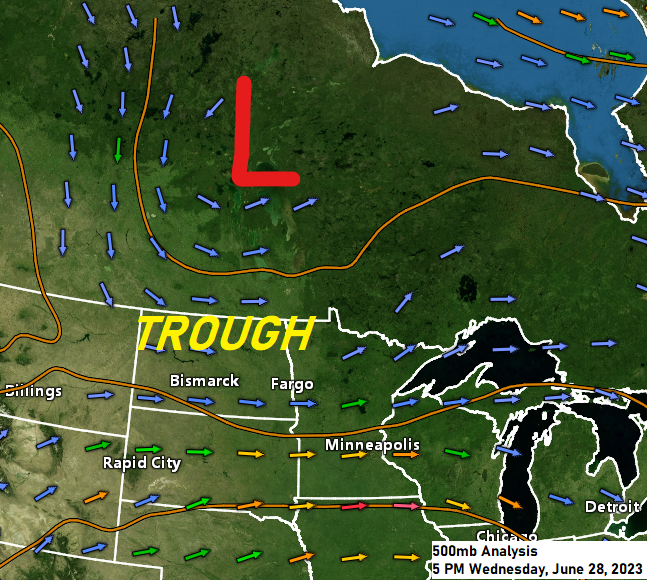
An upper level low/trough continues to dig south/east out of Saskatchewan and Manitoba and into the northern Plains and upper Midwest today and forcing associated with this system has caused more showers and thunderstorms to develop across the region today.
Goes-16 water vapor loop from Wednesday, June 28, 2023 (loop time ends 5 PM CT)

Regional radar image from late Wednesday afternoon.

Showers and some thunderstorms over northeast Minnesota and northwest Wisconsin late this afternoon will come to an end from SW-NE during the night, and then will see isolated to scattered showers and thunderstorms redevelop on Thursday, especially in the afternoon/early evening.
Note — The threat for severe thunderstorms is very low in the Northland for tonight and Thursday, but an isolated strong to severe thunderstorm cannot be ruled out especially Thursday afternoon-early evening.
18z NAM 3km model radar forecast through 7 PM Thursday.

Tim
Leave a Reply