6:48 PM Sunday, July 16, 2023
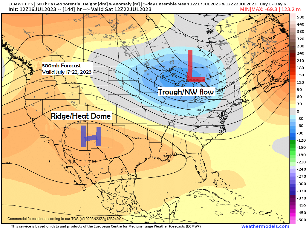
Northwest flow aloft will continue this week across the upper Midwest and Great Lakes as a large upper-level ridge remains nearly stationary over the southwest U.S., while an upper-level low/trough covers the upper Midwest, Great Lakes into central Canada.
With the Northland remaining under a NW flow for the next several days this will help keep the intense heat well to the southwest of our area.
Highs in the mid 60s to low 70s are forecast in our area Monday so in other words pretty similar to the highs we saw on Sunday. Temps warm a bit Tuesday with highs in the 70s to around 80 which is very close to normal for this time of year.
A few chances for rain will also continue this week, although no widespread rains are expected, except on Wednesday when there is a possibility for a somewhat more widespread rain event hitting some parts of the Northland.
Rainfall anomalies for July 2023 (thru 4 PM on the 16th)
International Falls, MN: -2.56″ below normal
Brainerd, MN: -2.23″ below normal
Duluth, MN: -2.19″ below normal
Hibbing, MN: -2.15″ below normal
Ashland, WI: -0.37″ below normal
Rainfall totals, departure and percent of normal rainfall since June 1st, 2023
Duluth, MN
Total: 4.44″
Departure: -2.19″ below normal
Percent of normal rainfall: 67% of normal
International Falls, MN
Total: 3.55″
Departure: -2.56″ below normal
Percent of normal rainfall: 58% of normal
Here’s the temperature anomaly forecast through July 22.
Below average temps in blue, green and purple.
Above average temps in orange, red and white.

Isolated rain showers will continue tonight and again during the day Monday with many dry hours likely in between these isolated showers, and similar to today, not everyone will be seeing any rain tonight or Monday.
Radar forecast through 7 AM Tuesday (Nam 3km model)

A system moving across the area Wednesday-early Thursday does have a better chance at producing a more widespread rainfall in much of northeast Minnesota and northwest Wisconsin, but this could change since this system is still a few days away.

As we get toward the end of the month there is a chance that we could see a large upper-level ridge covering the southwest U.S. expand a bit to the north/east with higher 500mb heights as well, and if this does happen, then the chances for much warmer temperatures would increase in much of the Northland with 80 and even 90 degree temperatures possible later this month.

Temperature anomaly forecast for July 24-29, 2023.

There’s no doubt that it’s very hot once again today over parts of the western and southwest U.S. with temperatures of 95 to 105 degrees or warmer this afternoon, while temperatures are holding in the 60s to lower 70s in northeast Minnesota and northwest Wisconsin.

Looking at the temperature anomaly from Sunday afternoon shows temperatures running about +5 to +15 degrees above average in parts of the western/southwest U.S., to -5 to -15 degrees below average from the Dakotas to Minnesota into much of Wisconsin and upper Michigan.

Thanks for reading!
Tim
Leave a Reply