6:00 PM Tuesday, July 11, 2023
There is a chance for a little light rain and drizzle at times tonight and Wednesday across parts of the Northland but a lot of us will likely miss out on getting this rain through Wednesday.
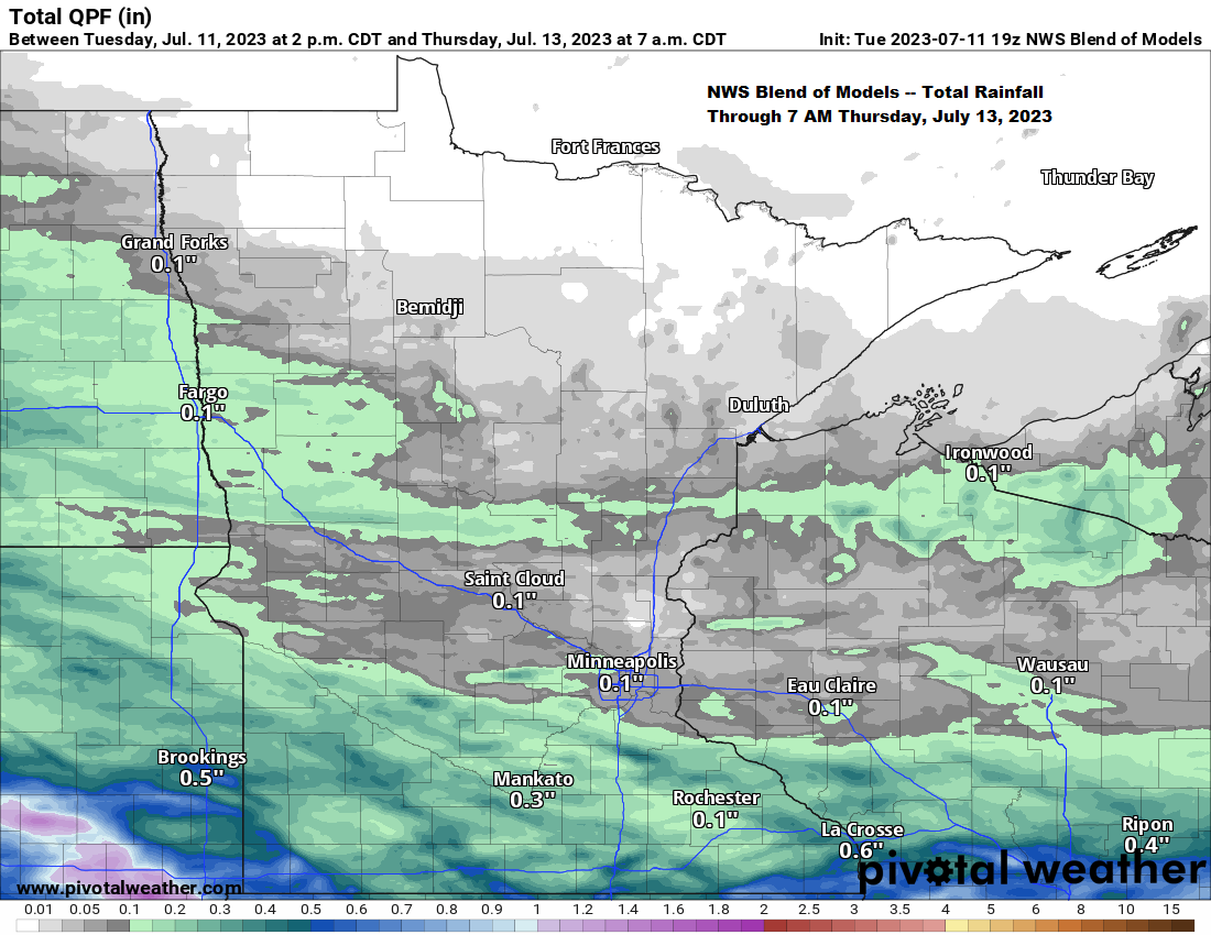
No strong signals showing up in the computer models for any widespread rain events impacting the Northland through at least early next week, but a few showers or thunderstorms are certainly possible from time to time due to a somewhat unsettled NW flow aloft over the area.
Temperature wise — Highs in the upper 60s to middle 70s Wednesday, and then mainly in the 70s with a few low 80s mixed in for Thursday, Friday and Saturday.
NAM 3km model radar forecast through 7 AM Thursday.

Average temperatures in the Northland so far this month are running around average to as much as -3.0 degrees below average – See below.
Brainerd, MN: 66.4 degrees, -2.9 degrees below average
Ashland, WI: 65.6 degrees, -0.1 degrees below average
Duluth, MN: 65.3 degrees, -0.7 degrees below average
International Falls, MN: 62.3 degrees, -2.0 degrees below average
Hibbing, MN: 60.4 degrees, -2.4 degrees below average
3 days so far this month with a high temperature of 80 degrees or warmer at Duluth. The average number of days in July with a high of 80 or warmer is 12 days.
Note – Cooler than average temperatures in green, blue and purple on the map below, with warmer than average temperatures in orange and red.

Widespread heat continued today near a strong upper-level ridge over the southwest U.S., into the central Rockies while a strong upper-level low near Hudson Bay Canada keeps a cooler northwest flow aloft in place over the upper Midwest and Great Lakes today.

In between the heat to the southwest and coolest air over central Canada we have a few disturbances dropping SE which is leading to areas of rain and thunderstorms this afternoon across parts of the northern Plains and upper Midwest.
Note — Not all of the precipitation showing up on radar in western and central Minnesota is reaching the ground late this afternoon due to a lot of dry air aloft, but there are some locations which are reporting light rain and drizzle as of 5 PM today.


Goes-16 water vapor loop from Tuesday, July 11, 2023 (loop time ends 5:50 PM CT)

Scattered strong to severe thunderstorms over eastern Montana and the western Dakotas are moving to the southeast, while some lighter rains over eastern North Dakota and western/central Minnesota moves toward the east-southeast late this afternoon.
Radar loop from Tuesday, July 11, 2023 (loop time ends 5:15 PM CT)

Thanks for reading!
Tim
Leave a Reply