6:18 PM Tuesday, July 25, 2023
A complex of thunderstorms is forecast to develop over eastern North Dakota late this afternoon and this complex of storms is then forecast to drop south/southeast through western into south-central Minnesota tonight. A cold pool left behind this complex of storms combined with lingering cloud cover and a potential for a stronger NE wind near Lake Superior Wednesday morning means that high temperatures for Wednesday afternoon could end up cooler than what is currently forecast.
A separate area of showers with embedded thunderstorms could move through parts of far northern Minnesota, Arrowhead and far northern Wisconsin early Wednesday morning but there’s lower confidence that will see this rain actually develop later tonight.
Nam 3km model radar forecast through 1 PM Wednesday.

As I mentioned above, we could see a few hours with a pretty strong northeast wind near Lake Superior including in the Duluth and Superior area Wednesday morning with a potential for wind gusts of 25 to 30 mph with a few higher gusts. Winds are expected to diminish Wednesday afternoon.
NAM 3km model wind gust forecast valid 6 AM to 12 PM Wednesday.

More widespread rains/higher rainfall amounts north and south of the Northland tonight with mostly scattered rains if any for much of the Northland.
Rainfall forecast through 7 PM Wednesday.

Isolated strong to severe thunderstorms (dark green area on map) are possible late tonight/early Wednesday morning across northern Minnesota with the primary severe weather threats being large hail to quarter size or 1″ diameter, and wind gusts to 60 mph.
Note — There is a greater chance for severe thunderstorms tonight/early Wednesday morning over parts of west central into southern Minnesota.

High temperature reports from Tuesday, July 25, 2023
Brainerd, MN: 95 (record high 99 set in 1931)
Hibbing, MN: 88 (record high 90 set in 1949, 1961 and 1999)
Ashland, WI: 88 (record high 95 set in 1931)
Duluth Airport: 87 (record high 89 set in 1874, 1892 and 1989)
International Falls, MN: 77 (record high 92 set in 1949)
Note — We’re now up to 7 days with a high of at least 80 degrees in Duluth this month (thru July 25) average number of days with a high of at least 80 in July is 12 days.
A closer look at temperatures across the Northland from late this afternoon — 91 degrees at Moose Lake, 90 degrees at Solon Springs, but an east wind continues to keep it cooler by Lake Superior with Superior checking in at 74 degrees, and Duluth Sky Harbor Airport had a temperature of 68 degrees at 4 PM today.

The big heat dome which has been over the southwest US has expanded more to the north/east over the last few days with higher 500mb heights and a very warm air mass now in place across the Northern Plains and upper Midwest, but here in the Northland we remain on the NE edge of this heat dome which means that the very warm temperatures occurring away from Lake Superior will only stick around for another day or two before we see cooler temperatures return area-wide starting on Friday.
By the way, near the center of the upper-level ridge over the southwest US we’re seeing 500mb heights >6000 decameters for the 2nd day in a row, so needless to say this continues to be a very strong upper-level high pressure system.

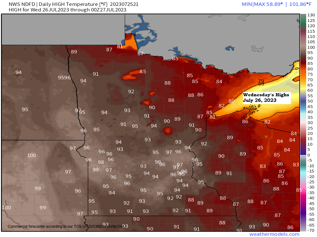
Widespread 90s showing up once again this afternoon across the region, but 80s are more common across northern Minnesota and far northern Wisconsin.

It was also pretty muggy this afternoon in some parts of the Northland including for locations near Lake Superior where we had dew points ranging from 65 to 70 degrees, but it’s slightly less humid around the Brainerd Lakes area with dew points around 60 late this afternoon.
A humid air mass (dew points of 60+) will remain over the Northland Wednesday and possibly even into Thursday with a drier air mass returning by Friday the way it looks now.

A dry July in much of the Northland.
Here’s a look at total rainfall, departure and percent of normal rainfall for July 2023 (thru 4 PM on the 25th)
Brainerd, MN
Total: 0.58″
Departure: -3.69″ below normal
Percent of normal rainfall: 15% of normal
Duluth Airport
Total: 1.20″
Departure: -2.08″ below normal
Percent of normal rainfall: 37% of normal
Ashland, WI
Total: 1.98″
Departure: -1.16″ below normal
Percent of normal rainfall: 64% of normal
International Falls, MN
Total: 2.22″
Departure: -1.15″ below normal
Percent of normal rainfall: 66% of normal
Hibbing, MN
Total: 2.66″
Departure: -0.61″ below normal
Percent of normal rainfall: 81% of normal

Thanks for reading!
Tim
Leave a Reply