6:12 PM Friday, August 11, 2023
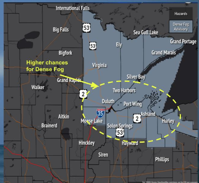
Areas of fog are likely in the Northland later tonight lingering through about mid-morning on Saturday, and some of this fog could be dense especially around Lake Superior with visibility of one quarter mile or less.
Scattered showers and thunderstorms will continue to move southeast across parts of the Northland this evening, and there is a chance that will see a few popup showers on Saturday but coverage of any rain on Saturday should be much less compared to what we saw Friday afternoon.
Sunday morning looks mainly dry across the Northland, but another system approaching from the Dakotas could bring more rain to the area Sunday afternoon/evening through Monday morning, but computer models are beginning to diverge on how they handle this system, with at least somewhat of a trend toward a farther west/south track to this system, which could mean that much of the Northland misses out on getting anything more than some light rain late Sunday-early Monday.
Nam 3km model radar forecast through 10 PM Saturday.

A strong mid/upper-level low pressure digging southeastward into Minnesota led to an eruption of scattered strong to severe thunderstorms this afternoon from parts of south central to east central Minnesota into far western Wisconsin.
Here’s a look at this upper low moving into Minnesota via Goes-16 water vapor loop from Friday, August 11, 2023 (loop time ends 4:30 PM CT)

Sandwich satellite loop shows the convection nicely as it builds south out of eastern Minnesota and western Wisconsin into southern Minnesota late this afternoon (Loop time ends 4:36 PM CT Friday, August 11, 2023)

Radar loop ending 5:50 PM Friday, August 11, 2023.

As I mentioned above, I’m starting to see some disagreement in the computer models in regard to Sunday’s system.
The NAM forecast continues to show a widespread rain event hitting the Northland with more of a closed 500mb low and a farther north track to this system.

But the Euro model has trended more toward an open wave and a farther west/south track to the system on Sunday which would mean that much of the Northland would be on the northern fringes of this system with mostly some light rain except for possibly the far southern portion of the Northland where heavier rain is still possible.

Note the trend in the EPS model on where the highest chances for a half inch to an inch or more of rain will be for Sunday-early Monday.
Started over northern Minnesota and northern Wisconsin Thursday morning, but now has shifted south into central/southern Minnesota into western/central Wisconsin per today’s run.


Thanks for reading!
Tim
Leave a Reply