5:16 PM Monday, August 14, 2023
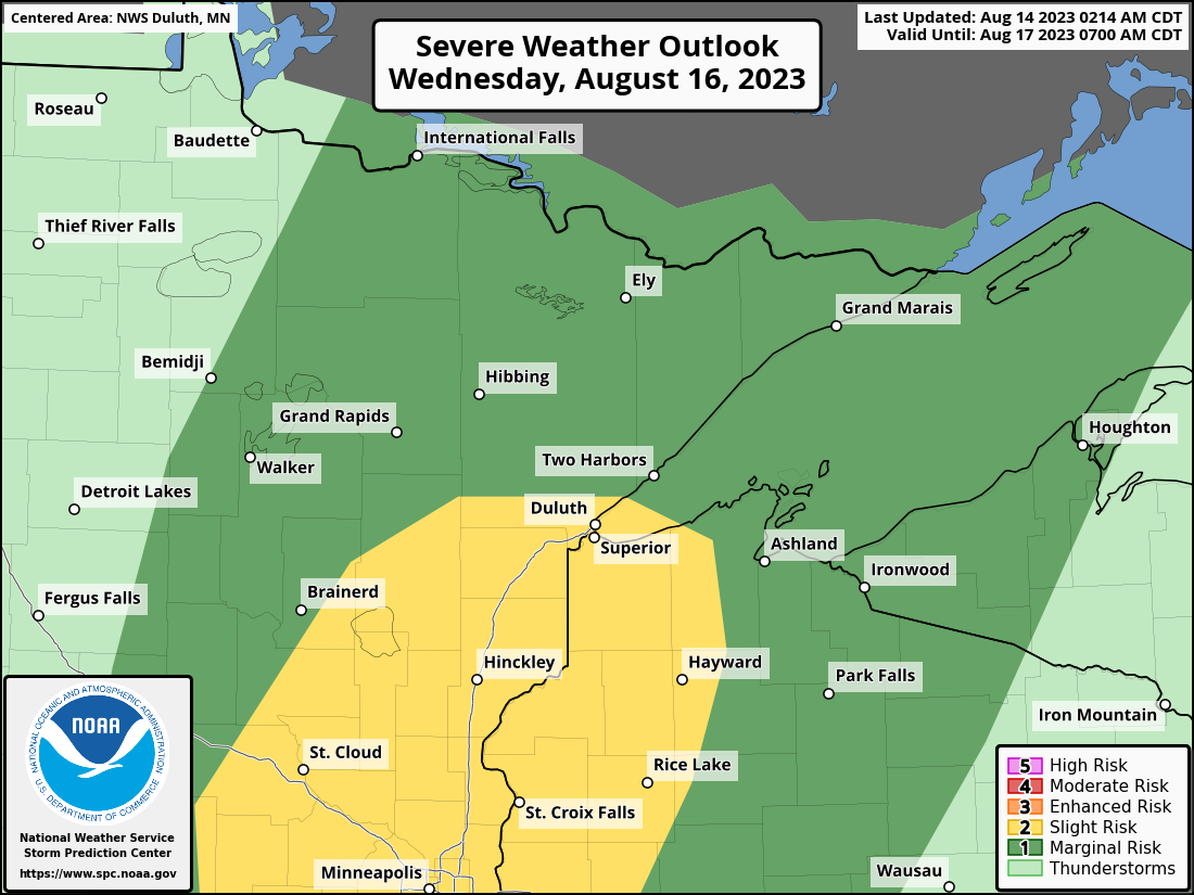
Isolated to scattered strong to severe thunderstorms are possible Wednesday afternoon into Wednesday evening across the Northland, with the greatest chances looking to be over east central Minnesota into far northwest Wisconsin.
A strong upper-level trough will be digging southeast out of Manitoba on Wednesday while a cold front moves quickly southeast out of the Dakotas. Strong southerly winds ahead of this system will advect a very warm and humid air mass northward into our area on Wednesday with temperatures in the 80s to around 90 along with dew points in the low to mid 60s. CAPE should increase to around 800-1700 J/kg Wednesday afternoon-evening, with mid-level lapse rates of around 7.0 C/km. Winds aloft look very strong on Wednesday with strong amounts of wind shear (both directional and speed shear) also over the Northland.
The overall environment late Wednesday afternoon into Wednesday evening favors squall line development or a broken line of storms with a damaging wind threat, but some large hail is also possible. The tornado risk continues to look pretty low on Wednesday despite the strong amounts of shear and turning of wind direction with height. Low-level moisture looks somewhat limited on Wednesday which should also limit the threat for tornadoes with overall higher cloud bases due to the somewhat marginal amounts of moisture over the Northland.
Here’s the 500mb forecast valid 7 AM Wednesday to 7 AM Thursday. This midweek system is a strong one as noted by the darker blue and purple colors (see animation below) which dig southeast through the upper Midwest and western Great Lakes.

One of the factors which may hinder thunderstorm development Wednesday afternoon are these warmer temperatures in the atmosphere with the +10C 700mb temperature contour reaching up into central Minnesota before it pushes southeast Wednesday evening in response to the approaching trough from the northwest. Note — If this cap ends up stronger than modeled, or if this cap doesn’t break then we might not see very many thunderstorms in our area Wednesday afternoon/evening.

For Duluth: Showers and thunderstorms (a few of which could be strong to severe) are possible from around 5 PM to 8 PM Wednesday the way it looks now.
Here’s the Nam 3km model radar forecast valid from 1 PM Wednesday to 11 PM Wednesday.

Rainfall Anomalies for August 2023 (thru 4 PM on the 14th)
Ashland, WI: -1.48″ below normal
Duluth, MN: -1.21″ below normal (-4.03″ below normal since June 1)
Hibbing, MN: -0.63″ below normal
Brainerd, MN: +0.82″ above normal
International Falls, MN: +0.23″ above normal
A cold front moving south to the Ontario/Minnesota border late Tuesday could spark a few showers and thunderstorms in far northern Minnesota and over the Arrowhead, but a greater chance for scattered rains occurs Wednesday afternoon/evening with rainfall totals ranging from around 0.10″ to 0.50″, but higher amounts are possible with thunderstorms.

Area outlined in red on the map below represents stronger vertical lift in the atmosphere which will move southeast out of north central Minnesota late Wednesday afternoon, and as that stronger lift moves southeast into a warm, humid and unstable air mass, we should see some stronger storms develop.

A strong upper-level ridge with 500mb heights of 594 to around 600 dam is forecast to setup over the Midwest this weekend into early next week, but at the moment it looks like the most persistent and hottest temperatures will remain well to the south of the Northland next week, but we are looking at a couple of warm days through this weekend, including Tuesday and Wednesday, and again Saturday and possibly on Sunday…Temperatures on each of those afternoons should climb into the 80s, with a few 90s even possible Wednesday, and again on Saturday.

Temperature anomaly forecast for August 21-26, 2023.
Again, it looks like the most persistent heat for next week will stay south of the Northland with highs in our area generally in the 70s with 60s near Lake Superior due to a breezy NE wind early next week.

A strong low-pressure system continues to move southeast out of northeast Iowa this afternoon. This is the system that brought widespread rain to central and southern Minnesota and western and central Wisconsin Sunday night into Monday morning.
Goes-16 water vapor loop from Monday, August 14, 2023 (loop time ends 4:51 PM CT)

12-hour radar estimated rainfall totals ending at 12 PM Monday.

Rainfall Reports from across the Northland from August 13-14, 2023
Source: MesoWest; National Weather Service Duluth, MN
2 SE Spooner, WI: 1.27″
1 SSW Pine City, MN: 1.12″
Shell Lake, WI: 0.83″
Spooner, WI: 0.66″
Siren, WI: 0.55″
Brainerd, MN: 0.43″
Winter, WI: 0.35″
McGregor, MN: 0.25″
Hayward, WI: 0.20″
Aitkin, MN: 0.16″
Minong, WI: 0.16″
Glidden, WI: 0.14″
Clam Lake, WI: 0.09″
Moose Lake, MN: 0.04″
Solon Springs, WI: 0.04″
Pine River, MN: 0.01″
Thanks for reading!
Tim
Leave a Reply