5:35 PM Friday, August 18, 2023
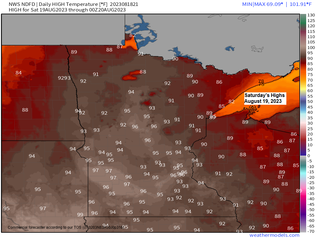
A very warm and also a very muggy Saturday is ahead in the Northland with high temperatures in the upper 80s to middle 90s while dew point temperatures climb quickly into the 65 to around 75-degree range Saturday afternoon into Saturday evening, so it will be a rather oppressive day for heat and humidity in our area on Saturday, but this heat and humidity will be short lived as cooler and much drier air returns on Sunday.
***Record Highs for August 19***
Brainerd, MN: 100 set in 1976
Ashland, WI: 97 set in 1976
Hibbing, MN: 95 set in 1976
Duluth, MN: 94 set in 1976
International Falls, MN: 94 set in 1959 and 1976
Note — Probably won’t be tying or setting any new record highs in the Northland on Saturday, but either way it’s going to be a very warm afternoon with temperatures running about +10 to +20 degrees warmer than average for August 19th.
It won’t feel too humid in our area Saturday morning, but that will quickly change Saturday afternoon as a cold front approaches from the west which will help pull an area of very muggy air northward into the Northland which will linger into Saturday evening before a much more comfortable air mass returns for Sunday.

Heat Advisories and Excessive Heat Warnings have been issued for Saturday afternoon into Saturday evening south of the Twin Ports.

Temperatures aloft will be very warm Saturday afternoon with 925mb temperatures reaching into the +25 to +30C range over the Northland, and this much warm air will prevent any thunderstorm from developing as a cold front moves through the area later in the day Saturday.

The next few days look dry across the Northland, but I am keeping an eye on the Monday-early Tuesday morning time frame, this is when we could see some showers and thunderstorms develop in parts of the area as a very warm, humid and unstable air mass to our south collides with a cooler/drier and more stable air mass to the north. Sometimes this type of pattern can lead to the development of elevated thunderstorms and heavy rainfall so this will be something to monitor through this weekend to see how the models trend for Monday.
The computer models do show an area of very strong instability with CAPE >2000 J/kg setting up across central Minnesota Monday night. Storms would tend to develop slightly north/northeast of this very unstable air mass. Temperatures aloft do look plenty warm, however Monday night with 700mb temperatures of around +12C, so this could squash any thunderstorm from developing.

Getting to be that time of the year where we see pockets of fall like temperatures during the early mornings. Won’t be long now before we’re talking about the first frost/freeze in the Northland.
Temperatures on the map below were from 5 AM Friday, August 18, 2023 — Note the upper 30s in a few locations in northeast Minnesota early this morning.

Thanks for reading!
Tim
Leave a Reply