4:24 PM Saturday, August 19, 2023
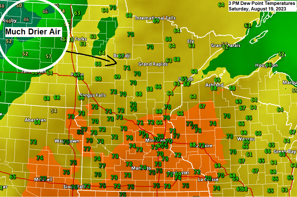
A very muggy air mass will linger in the Northland through this evening with dew points in the 60s to lower 70s, but a much less humid air mass currently over eastern North Dakota this afternoon will move over the Northland on Sunday with dew points falling into the 40s and 50s.
It’s a very warm Saturday afternoon in much of the Northland with temperatures in the 80s with even warmer temperatures in the lower 90s a little father to the west/south this afternoon.
Cooler temperatures arrive Sunday with highs in the 70s to around 80 in northeast Minnesota and northwest Wisconsin.

Heat index or feels like temperatures aren’t too bad in northeast Minnesota and northwest Wisconsin this afternoon, but we are seeing widespread and much warmer heat index values in the 90s across central and southern Minnesota into western Wisconsin this afternoon with even a few 100s mixed in over southwest Minnesota.

Check out these forecasted temperatures by the NAM model for this coming Tuesday.
Potential is there for temperatures exceeding 100 degrees Tuesday afternoon across south central Minnesota into southwest Wisconsin while temperatures might struggle to get out of the 60s in northeast Minnesota including in the Twin Ports on Tuesday.

I’m still keeping an eye on the potential for some showers and thunderstorms over parts of the Northland Monday into early Tuesday, with the most favored area for this to occur being over the Arrowhead of Minnesota including the North Shore, southeast into far northern Wisconsin (Bayfield Peninsula area)
Strong instability with elevated CAPE >2500 J/kg will be sitting over central Minnesota Monday night while a pretty strong low-level jet out of the southwest leads to a warm air and moisture advection pattern across the Northland. This type of setup can lead to heavy rainfall potential as storms would tend to develop to the NE of where the highest instability will be, and also to the NE of a strong cap or warm layer aloft which in this case will consist of 700mb temperatures approaching +14C over central Minnesota.

The black outlined area on the map below is where we could see locally heavy rain develop Monday night into early Tuesday morning.

More wildfire smoke will move through the Northland tonight and Sunday behind a cold frontal passage this evening. Some of this smoke could mix down to the surface, otherwise this smoke will remain aloft resulting in a hazy looking sky.
HRRR model smoke forecast through 7 PM Sunday.

Thanks for reading!
Tim
Leave a Reply