6:25 PM Monday, August 21, 2023
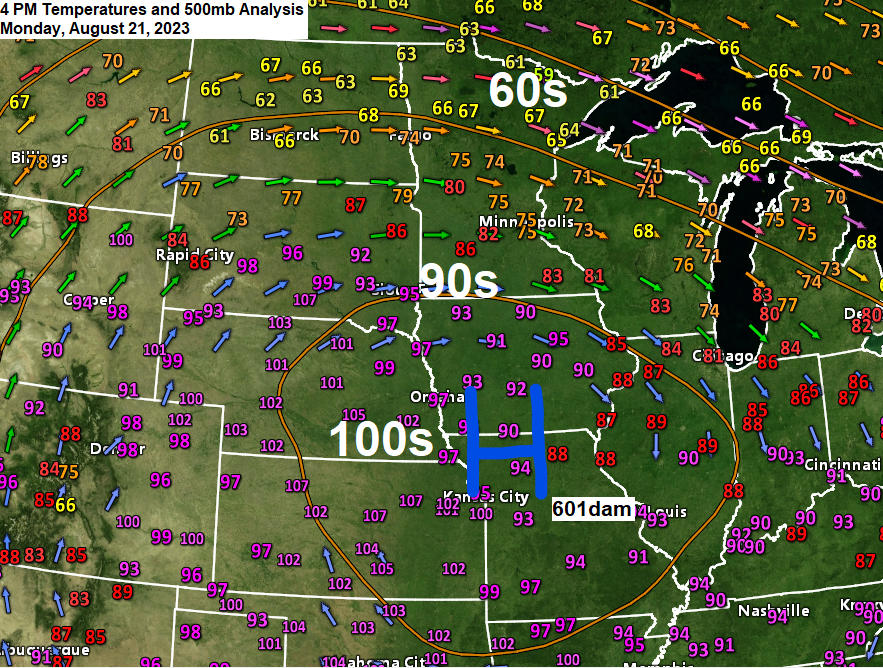
A massive heat dome with 500mb heights of 601dam was over the Central Plains this afternoon and temperatures are cooking under this upper-level ridge today with widespread 100s across the Central Plains while heat index values ranged from around 110 to 125 degrees late this afternoon.
The northern extent of this heat has pushed into far southern Minnesota this afternoon with temperatures in the lower 90s, while northern Minnesota was stuck in the 60s.
A potentially bumpy night is ahead in parts of northeast and east central Minnesota into northern Wisconsin as extreme amounts of instability with CAPE >4500 J/kg lifts north/northeast out of southern Minnesota with the help of a strengthening nocturnal low-level jet stream, but there is uncertainty in the computer models on where we could see thunderstorms develop late tonight, and once they develop how long those storms train/move over the same location for, because the potential is there for some significant rainfall totals in a short period of time early Tuesday morning, and although much of the Northland has been in a drought much of this summer, the amount of rain which may fall on a localized basis early Tuesday morning could be enough to produce isolated instances of flash flooding especially over parts of eastern Minnesota into parts of northwest Wisconsin early Tuesday morning.

Thunderstorms that do develop late tonight will be capable of producing frequent lightning and very heavy rainfall with a few storms possibly turning severe (dark green area on map) with the main threat coming from hail which could reach quarter to ping pong ball size (1″ to 1.5″ diameter)

850mb warm front marked by the change in wind direction from SW behind the warm front to SE ahead of the warm front is typically where will see elevated thunderstorms develop, so will see how things play out late tonight.

Looks like will see scattered showers and thunderstorms develop over parts of east central and northeast Minnesota into parts of northwest Wisconsin late tonight, or somewhere in the 11 PM to 2 AM time frame. Storms diminish around 7 to 9 AM Tuesday.
HRRRv4 radar forecast through 10 AM Tuesday.

Rainfall forecasts through 1 PM Tuesday.
Note — The black outlined areas on the maps below represent where we could see rainfall totals of 1-2″ with the NAM 3km model going as high as 3 to around 5″ of rain.
Euro model is a little more to the north on the placement of heavy rain early Tuesday morning.

Whereas the NAM 3km model is further south.

And then we have the middle of the road solution between the farther north Euro to the farther south NAM 3km model which would be the NWS Blend of Models.

***LATE AUGUST HEAT WAVE***
Widespread excessive heat warnings (purple like color) and excessive heat watches (dark red) and heat advisories (orange like color) stretch from central Minnesota and central Wisconsin south to Texas and east to Georgia.

Temperatures are hot enough across the Central Plains today, but then you factor in the dew points, and you have a real problem as heat index or feels like temperatures have been in the 110s and 120s in parts of Nebraska, Iowa, Kansas and Missouri this afternoon.

Beyond oppressive is how to describe some of these dew points this afternoon, and I’ve even seen a few locations in western Iowa which have reported dew points in the low 90s this afternoon! A dew point of 65 is considered muggy by the way.

Here’s a look at heat index temperatures from late Monday afternoon.

Closer look at temperatures in Minnesota from late Monday afternoon.
Lower 90s in southwest Minnesota to the upper 50s in far northeast Minnesota.

Will likely be seeing an even greater temperature contrast in Minnesota Tuesday afternoon compared to what we saw Monday afternoon.
925mb temperatures around +38C in southwest Minnesota to around +12C in northeast Minnesota Tuesday afternoon.

Tuesday might be one of those days where you travel south of Duluth and watch the temperatures go from the 60s in Duluth to the 90s about an hour or so south of Duluth, and then if you travel even further south, you’ll get into 100-degree temperatures from around the Twin Cities on south.
Note — A northeast wind will likely continue in Duluth through Wednesday keeping temperatures on the cool side, but we might see temperatures warm to around 80 on Thursday as we get rid of the lake wind.

Thanks for reading!
Tim
Leave a Reply