6:34 PM Wednesday, August 23, 2023
Will finally get rid of the strong northeast wind near Lake Superior including in the Twin Ports on Thursday, but before that happens will see another night of breezy northeast winds with more fog and mist with some dense fog with visibilities down to a quarter mile at times. This fog will likely linger through about mid-morning on Thursday before conditions improve Thursday afternoon with warmer temperatures in the 70s to lower 80s along with a muggier feel as well as dew points rise into the middle 60s Thursday afternoon.
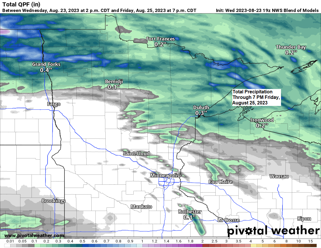
Rain totals don’t look very impressive the next few days, but we likely will see at least some showers and perhaps a few thunderstorms at times through Friday. Rain chances tonight will be highest across northern Minnesota, then that area will shift into northeast and eastern Minnesota and northwest Wisconsin on Friday, but again we’re not looking at anything widespread in terms of rain the next few days.
Note — Duluth is running -4.16″ below normal in precipitation since June 1st, and -1.34″ below normal this month (thru 4 PM on the 23rd)
Scattered rains possible mainly over northern Minnesota tonight into early Thursday morning. And then we could see some more showers and a few thunderstorms late Thursday night through Friday morning in parts of the Northland with mainly dry conditions Friday afternoon the way it looks now.
NAM 3km model radar forecast through 7 PM Friday.

The pattern remains nearly the same as it has been the last few days with a frontal boundary draped from southern Minnesota to central Wisconsin, so a little farther south compared to 24 hours ago. This front separates very hot and humid conditions south of the boundary, with much cooler temperatures north of the boundary.
Upper-level ridge although still strong does continue to weaken slightly today while also shifting farther to the south compared to where it was a few days ago. 500mb heights near the center of the upper ridge have dropped to around 595 decameters this afternoon. A few days ago, 500mb heights near this ridge were up to 601 decameters.

Low clouds and areas of fog continued today over much of the Northland with the fog mostly burning off this afternoon.
Goes-16 visible satellite loop from Wednesday, August 23, 2023 (loop time ends 5:36 PM CT)

As I’ve been pointing out for several days now, the core of the heat ended up staying south of the Northland, which I’ve been saying would happen for several days now (not to toot my own horn or anything. Just pointing out what happened)
Here’s a look at temperatures from Wednesday afternoon.

Heat index values of 100 to around 120 degrees once again this afternoon across much of the Midwest.

Widespread mugginess continues today with dew points in the mid 60s to low 80s with lower dew points near Lake Superior due to the temperatures being much cooler compared to areas farther south. A humid air mass will linger Thursday and Friday before drier air moves in this weekend.

***SNOWFALL FORECAST***
A few areas in Canada could get a little snow over the next 2 weeks, but nothing major in terms of snow yet.

Thanks for reading!
Tim
Leave a Reply