4:33 PM Friday, September 1, 2023
Early September heat wave began today, and temperatures over the next few days will only be trending hotter. Could we see a city or town in the Northland hit 100 degrees on Sunday? That is a possibility!
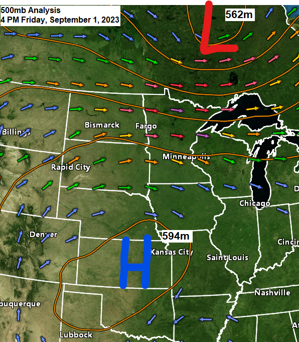
Looking at the upper-level pattern this afternoon shows a large upper-level ridge with 500mb heights of around 594 decameters covering the Midwest while an upper-level trough passes north of Lake Superior as it moves east across Ontario today.
Temperatures this afternoon although on the warm side weren’t too bad with highs mostly in the 80s in northeast Minnesota and northwest Wisconsin with a few 90s mixed in elsewhere in Minnesota, but there is a larger reservoir of heat covering areas of South Dakota and nearly all of Nebraska today, and it’s this air mass that the Northland will start to tap into over the next few days.
High temperatures for Saturday, Sunday and Labor Day will be running in the 85-to-95-degree range across the Northland with a few locations possibly getting as warm as the upper 90s on Sunday and possibly on Labor Day as well. It won’t be until mid to late next week before we see temperatures cool back down toward normal which at this time of year would mean highs in the lower 70s. Overnight temperatures through Tuesday will mostly be in the 60s with some 50s in the typical cool spots across the area.
Note — Although isolated showers or thunderstorms can’t be ruled out in parts of the Northland tonight through Labor Day, I’d say about 95 to 99% of the area including the Twin Ports will stay dry at least through Tuesday morning the way it looks now.
Here’s a look at the record high temperatures over the next few days — There’s a pretty good chance that will see a few new record highs set in the Northland the next few days.
September 2nd
Ashland, WI: 97 set in 1929
Brainerd, MN: 93 set in 1929
Duluth, MN: 92 set in 1983
International Falls, MN: 92 set in 1971
Hibbing, MN: 91 set in 1983
September 3rd
Brainerd: 96 set in 1983
Ashland: 95 set in 1983
Duluth: 89 set in 1960
International Falls: 88 set in 1960
Hibbing: 87 set in 1971
September 4th
Ashland: 93 set in 1922
Brainerd: 93 set in 1960
International Falls: 91 set in 1922
Duluth: 89 set in 1897
Hibbing: 89 set in 1978

It was slightly humid in the Northland today with dew points around 60 and expect similar dew point temperatures over the next few days with some parts of the Northland seeing dew points in the 60s, while other areas see lower dew points down into the 50s at times. Note — Anytime the dew point is 60 or above it does make it feel pretty muggy outside.

Well above average temperatures are likely across the Northland this weekend through about the middle of next week.

As we get into next weekend and into the following week, we could see cooler temperatures in the Northland although still running a little above average for this time of year the way it looks now.

We did see a small area of showers and thunderstorms move through southern portions of northwest Wisconsin this morning into early this afternoon.
Note — Hayward did pick up 0.09″ of rain from this morning’s thunderstorms.

A few of these storms did produce some hail (sub-severe) around the Hayward, WI area late this morning with reports of hail up to the size of a dime (0.70″ diameter)

Thanks for reading!
Tim
Leave a Reply