7:05 PM Sunday, September 3, 2023
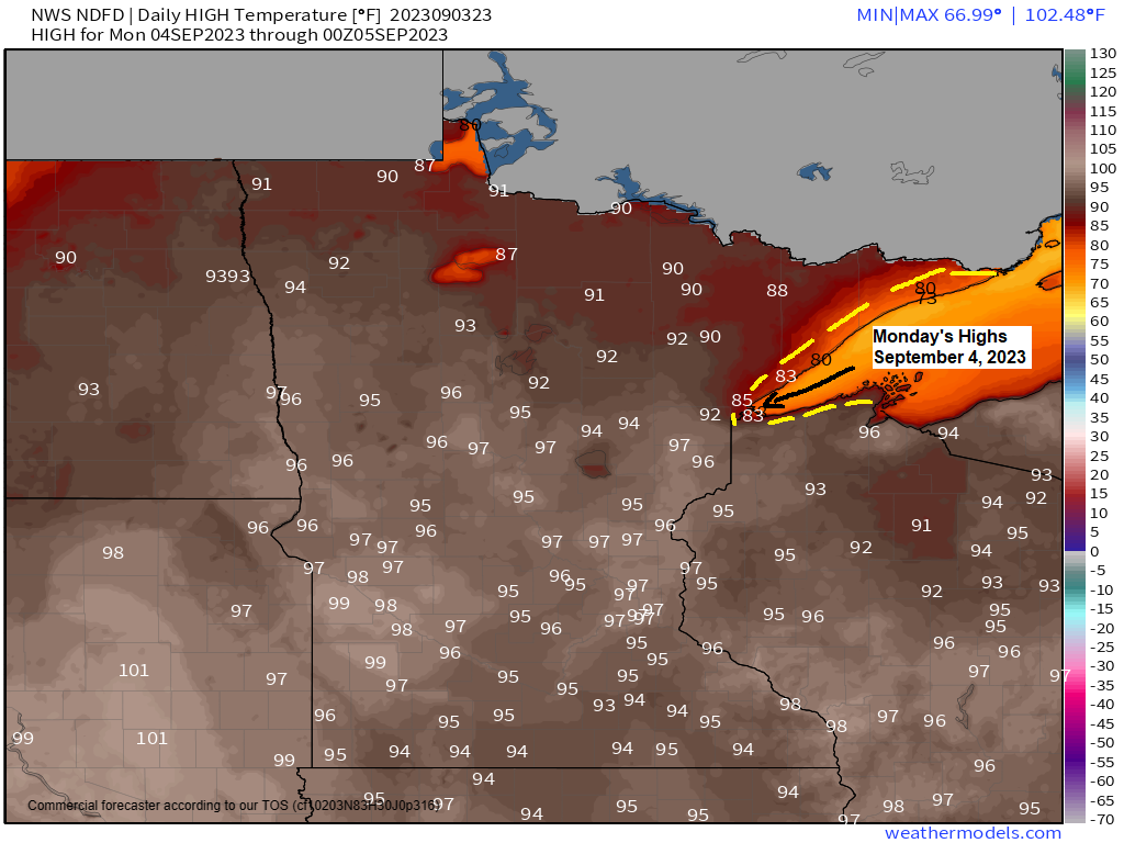
Another hot day ahead for Monday with highs in the low to mid 90s in northeast Minnesota and northwest Wisconsin, but there will be one difference on Monday and it’s that winds will become northeast near Lake Superior and Twin Ports which will lead to cooler temperatures in the 70s to around 80 within about 10 to 15 miles of Lake Superior.
***RECORD HIGHS FOR SEPTEMBER 4TH***
Ashland, WI: 93 set in 1922
Brainerd, MN: 93 set in 1960
International Falls, MN: 91 set in 1922
Duluth, MN: 89 set in 1897
Hibbing, MN: 89 set in 1978
Note — The warmth sticks around on Tuesday with highs in the mid 80s to around 90, but this will be followed by much cooler temps for Wednesday and Thursday with highs mostly in the 60s which is actually a little below average for this time of year.

Heat wave continued in the Northland today with widespread temperatures in the 90s this afternoon with even a few 100s reported (Brainerd and Moose Lake)
New daily record highs were set in the Northland today, and a few locations even broke their warmest temperature on record for the month of September today — See list below.
***NEW DAILY RECORD HIGHS SET TODAY, SEPTEMBER 3, 2023
Brainerd: 102 — Previous daily record high 96 set in 1983
Duluth: 97 — Previous daily record high 89 set in 1960
Hibbing: 95 — Previous daily record high 87 set in 1971
***NEW MONTHLY HIGH TEMPERATURE RECORDS SET TODAY, SEPTEMBER 3, 2023***
Duluth: 97 — Previous monthly record high 95 set in 1976 (weather records for Duluth date back to 1874)
Hibbing: 95 — Previous monthly record high 94 set in 1976 (weather records for Hibbing date back to 1938)
Note: The high of 102 at Brainerd today (9/3/2023) is only the 2nd time in station history where the temperature reached at least 100 degrees during the month of September. The only other time this happened was in September 1931 (high of 103 on the 10th) Weather records for Brainerd date back to 1899.

Dew points were all over the place this afternoon with some parts of the area seeing much lower dew points (drier air) in the 50s, while other parts of the area had dew points in the 60s to lower 70s (very muggy)

Heat index or feels like temperatures ranged from the mid 90s to low 100s this afternoon in parts of central, eastern and southern Minnesota into north central Wisconsin.

A weak boundary over central Minnesota into far northern Wisconsin will lift north as a warm front through early Monday afternoon. There might be just enough lift near that aforementioned boundary to produce isolated showers or thunderstorms in parts of the Northland late tonight into Monday morning but most of us should stay dry through Tuesday morning.
NAM 3km model radar forecast through 7 PM Monday.

There is a greater chance for some rain and scattered thunderstorms across the Northland Tuesday afternoon into Wednesday as a cold front moves across the area, so hopefully will get some rain in much of the area because the pattern after Wednesday looks pretty dry once again.
Rainfall totals of around a quarter to three quarters of an inch are possible in northeast Minnesota and northwest Wisconsin Tuesday afternoon-Wednesday with an inch or more of rain possible in far northern Minnesota.

Still seeing a large upper-level ridge over the Midwest and Ohio Valley today with an upper-level trough over the western US, and an upper low over parts of the Southern Plains.

Water vapor loop from Sunday, September 3, 2023 (loop time ends 6:10 PM CT)

Warmer than average temperatures are likely in northeast Minnesota and northwest Wisconsin this week, although the warmest temps will occur through Tuesday, with cooler temps mid to late week.

What happens with the temperatures next week is uncertain right now with the Euro ensemble model going with below average temperatures across the Northland.

While the GEFS model (shown below) has temperatures running a little warmer than average across the Northland next week.
GEFS model temperature trend for September 11-16.
Old run is Days 11-15, and the newest run is Days 9-13 on the animation below.

Thanks for reading!
Tim
Leave a Reply