6:19 PM Thursday, September 7, 2023
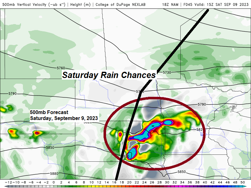
Dry weather for Friday, but some rain is possible Saturday as a cold front and disturbance move east out of the Dakotas.
There are differences in the computer models on the placement of this rain on Saturday, as well as on rainfall amounts.
NWS Blend of Models shows the rain being farther north Saturday compared to the European model which is farther south. Note — The Euro model showed the rain on Saturday farther north on its last 2 model runs (00z and 06z) but the newest model run being the 12z from today has shifted the area of rain farther to the south.

European model forecast

***ADDITIONAL STORM REPORTS FROM TUESDAY, SEPTEMBER 5, 2023***
Source: National Weather Service Duluth, Minnesota
Strong to severe thunderstorms developed from the Brainerd Lakes to the Iron Range and Arrowhead Tuesday afternoon and these storms continued into early Tuesday evening. There were numerous reports of damage due to strong thunderstorm winds as well as large hail across northeast Minnesota.


On Wednesday, September 6, 2023, NWS Duluth conducted a storm survey across portions of the Iron Range. There were scattered occurrences of moderate to major damage in the Hoyt Lakes, Aurora Bass Lake areas. The damage was determined to be due to strong straight-line winds with wind gusts estimated to be approximately 60 mph to 90 mph. Some wind gusts approaching 100 mph may have occurred in some of the hardest hit areas, which were south of Aurora and around Bass Lake.
3:45 PM 9/5: Thunderstorm Wind Gust. 90 mph. 3 W Skibo, MN — St. Louis County.
3:43 PM 9/5: Thunderstorm Wind Gust. 93 mph. 3 ESE Hoyt Lakes, MN — St. Louis County.
3:42 PM 9/5: Thunderstorm Wind Gust. 94 mph. 1 NE Hoyt Lakes, MN — St. Louis County.
3:32 PM 9/5: Thunderstorm Wind Gust. 88 mph. 5 S Aurora, MN — St. Louis County.
3:32 PM 9/5: Thunderstorm Wind Gust. 70 mph. 5 S Aurora, MN — St. Louis County.
3:31 PM 9/5: Thunderstorm Wind Gust 107 mph. 5 S Aurora, MN — St. Louis County.
Still seeing a lot of cloud cover across northeast Minnesota and northwest Wisconsin today in wake of the system which moved through on Tuesday, while sunnier skies were found farther to the west today.
Goes-16 visible satellite loop from Thursday, September 7, 2023 (loop time ends 5:06 PM CT)

If clouds are able to break up enough tonight, then we could see a patchy frost threat develop early Friday morning over parts of the Northland well inland from Lake Superior with a chance for temperatures to fall into the mid 30s to around 40 well inland from Lake Superior, but if clouds stick around, then temperatures will be in the 40s to around 50.
Note — No frost tonight in Duluth or Superior.

Warmer temperatures return to much of the Northland on Friday with highs in the low to mid 70s with temps near 80 even possible around the Brainerd Lakes area, but temperatures will be cooler farther east near Lake Superior with highs mainly in the 60s on Friday.

Thanks for reading!
Tim
Leave a Reply