6:27 PM Tuesday, September 12, 2023
The switch has been flipped (for now) from barely getting any rain or mostly scattered rain events for weeks/months to seeing several rain events, some significant over the past week or so in the Twin Ports including other locations near Lake Superior, and the result from this is that we’re seeing very impressive rainfall anomalies so far this month which are running some 200-300% or more above normal near Lake Superior. It’s almost like the pattern is trying to balance out, going from extremely dry conditions near Lake Superior where severe, extreme to even exceptional drought have been occurring for a few months to very wet as of late, interesting.
Updated rainfall totals, departure and percent of normal for September 2023 (thru 4 PM on the 12th)
Duluth, MN
Total: 4.65″
Normal: 1.43″
Departure: +3.22″ above normal
Percent of normal precipitation: 325% of normal
Hibbing, MN
Total: 3.45″
Normal: 1.31″
Departure: +2.14″ above normal
Percent of normal precipitation: 263% of normal
Ashland, WI
Total: 2.37″
Normal: 1.16″
Departure: +2.14″ above normal
Percent of normal precipitation: 204% of normal
Brainerd, MN
Total: 1.72″
Normal: 0.99″
Departure: +0.73″ above normal
Percent of normal precipitation: 174% of normal
International Falls, MN
Total: 1.57″
Normal: 1.24″
Departure: +0.33″ above normal
Percent of normal precipitation: 127% of normal

***FLASH FLOODING IN PARTS OF DULUTH MONDAY NIGHT***
An intense and nearly stationary band of rain parked itself on the north/northeast portions of the city of Duluth for a few hours Monday night. Rainfall rates underneath this band of rain ranged from around 1 to 2 inches/hour, and due to these high rainfall rates, we did see some flash flooding develop late Monday evening.
Here are some of the flash flood reports from Monday night, September 11, 2023.


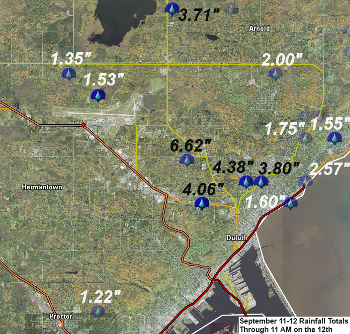
Radar rainfall estimates Monday night ranged from around 2 to 4 inches with localized greater amounts of up to 6 inches! The highest rain totals were centered over a small area on the north/northeast side of Duluth with lesser amounts of rain on the south side of Duluth including in the West Duluth and Proctor areas.

Rainfall Reports from September 11-12, 2023
Source: National Weather Service Duluth, Minnesota
3 NNW Duluth, MN: 6.62″
2 NNE Duluth, MN: 4.38″
1 NNW Duluth, MN: 4.06″
2 NNE Duluth, MN: 3.80″
2 W Rice Lake, MN: 3.71″
2 NNE Duluth, MN: 3.70″
2 NNW Duluth, MN: 3.69″
1 W Duluth, MN: 3.09″
3 SW Lester Park, MN: 2.57″
3 ESE Zim, MN: 2.21″
3 WNW Lester Park, MN: 2.00″
2 WNW Duluth, MN: 1.91″
2 N Lester Park, MN: 1.89″
1 ENE Hibbing, MN: 1.83″
Silver Bay, MN: 1.75″
3 NE Duluth, MN: 1.60″
Rice Lake, MN: 1.57″
4 NE Hermantown, MN: 1.53″
Canyon, MN: 1.50″
Duluth Airport: 1.45″
Chisholm-Hibbing Airport: 1.39″
3 N Skibo, MN: 1.34″
12 WNW Isabella, MN: 1.32″
5 NNE Biwabik, MN: 1.32″
2 SSW Meadowlands, MN: 1.31″
1 ENE Castle Danger, MN: 1.29″
2 SSE Independence, MN: 1.27″
2 ESE Floodwood, MN: 1.26″
1 NNW Beaver Bay, MN: 1.26″
4 SSW Shell Lake, WI: 1.25″
Embarrass, MN: 1.24″
4 WNW Two Harbors, MN: 1.17″
1 SE Two Harbors, MN: 1.15″
1 NW Palmers, MN: 1.13″
8 NNW Bovey, MN: 1.10″
Saginaw, MN: 0.89″
Ely, MN: 0.88″
Duluth Sky Harbor Airport: 0.62″
Hayward, WI: 0.46″
Solon Springs, WI: 0.44″
Hill City, MN: 0.39″
Washburn, WI: 0.21″
Glidden, WI: 0.21″
Clam Lake, WI: 0.14″
Minong, WI: 0.12″
Ashland, WI: 0.07″
Brainerd, MN: 0.07″
Siren, WI: 0.06″
Moose Lake, MN: 0.04″
We were likely seeing some lake effect rain showers or lake enhanced rains at the head of Lake Superior including in the Twin Ports this morning into early this afternoon with northeast winds coming down Lake Superior along with enough of a temperature difference from lake water temps (around +15C/60F) to 850mb temps which ranged from around -1C to +3C.

***FROST POTENTIAL TONIGHT***
Frost Advisory (blue area on map) in effect from 2 AM to 8 AM Wednesday.
Best chances for frost are away from Lake Superior in northeast Minnesota and northwest Wisconsin.

In order to get some frost tonight will need these clouds which are still widespread late this afternoon to break up allowing skies to clear and temperatures to drop low enough for frost formation later tonight.
Goes-16 visible satellite loop from Tuesday, September 12, 2023 (loop time ends 4:56 PM CT)

Definitely a fall feel out there across the Northland today with temperatures only in the 50s to around 60 degrees this afternoon which is about -10 to -15 degrees below average for September 12th.

Widespread 30s are forecast in northeast Minnesota and northwest Wisconsin early Wednesday morning with some 20s possible in the traditional cold spots, but again skies will have to clear in order for this to happen. Note — Temperatures will be a good 10 to 15 degrees warmer closer to Lake Superior tonight with no frost expected.

Rain chances return to the Northland late Thursday into early Friday as a low-pressure system with its warm front and cold front move across the area.

Parts of western Canada and Rockies could be getting some snow at times over the next few weeks with some significant snowfall amounts possible.
No signs will be getting any snow yet in northeast Minnesota or northwest Wisconsin over the next two weeks.

Thanks for reading!
Tim
Leave a Reply