5:31 PM Monday, September 25, 2023
Updated Rainfall Totals over the last few days, ending on the morning of Monday, September 25, 2023.
Source: National Weather Service Duluth, Minnesota
French River 2 NNW: 7.17″
Duluth 13.1 NNE: 6.59″
Two Harbors 5 N: 6.43″
Palmers 0.5 NW: 5.35″
Rice Lake 3 E: 5.00″
Duluth Airport: 4.59″
Wolf Ridge: 4.30″
Two Harbors: 4.26″
Silver Bay 0.4 W: 4.11″
Hermantown: 4.05″
Cotton 5.7 ESE: 3.57″
Superior 2 ENE: 3.48″
Cloquet 2.1 ESE: 3.18″
Aurora: 3.16″
Grand Rapids 6.1 SSE: 3.05″
McGrath 4.3 SE: 3.04″
Moose Lake: 2.72″
Eveleth: 2.64″
Grand Rapids: 2.55″
Grantsburg 0.6 SSW: 2.38″
Solon Springs 8.1 W: 2.35″
Wrenshall 9.7 SSE: 2.31″
Esko: 2.25″
Gordon 10.2 ENE: 2.21″
Webb Lake: 2.21″
Minong: 2.05″
Spooner 10.6 WNW: 1.89″
Clam Lake: 1.84″
Saginaw: 1.70″
Cook: 1.57″
Danbury: 1.43″
Hayward: 1.35″
Bayfield 1.7 SW: 1.31″
Bayfield 9 N: 1.22″
Walker: 1.21″
Deer River: 1.15″
Brainerd: 1.06″
Precipitation stats for Duluth, MN (Airport location)
Month to date precipitation total: 9.98″
Normal: 2.82″
Departure: +7.05″ above normal
Percent of normal precipitation: 354% of normal
Note — Duluth has had more precipitation this month compared to what we normally get for the entire fall (September, October and November). 9.98″ of precipitation so far this month, while the average for fall is 8.35″. If we don’t get any more precipitation the rest of this month, all of October and all of November, Duluth would still end with above average precipitation for fall 2023, incredible!
A look at the MRMS 72-hour precipitation analysis ending 8 AM Monday, September 25, 2023.

Local Storm Reports from September 24, 2023
Source: National Weather Service Duluth, Minnesota
12:30 PM: Flood. 3 NW Duluth, MN (St. Louis County) Parking lots of stores and restaurants flooded, intersection of Maple Grove and Mall Dr. and portions of Mall Drive between Maple Grove and Haines Rd also flooded.
12:19 PM: Flash Flood. 3 S Rice Lake, MN (St. Louis County) Tischer Creek was out of its banks and causing extensive flooding at the Ridgeview Country Club.
12:00 PM: Flash Flood. 3 WSW Lester Park, MN (St. Louis County) Tischer Creek was out of its banks and onto St. Marie Street just west of Woodland Ave.
12:00 PM: Flash Flood. 1 NNE French River, MN (St. Louis County) The culvert carrying Schmidt Creek under the NSSR tracks was washed out.
11:40 AM: Flood. 3 WSW Lester Park, MN (St. Louis County) Tischer Creek flooding Columbus Ave north of Arrowhead Road, road is blocked off by barriers.
11:27 AM: Flood. 3 WSW Lester Park, MN (St. Louis County) Tischer Creek flooding St. Andrews Street with water flowing over the road.
11:00 AM: Flood. 3 SW French River, MN (St. Louis County) A few washed out road culverts and other road washouts along Superior Street/Old North Shore Road between Lakewood Rd and McQuade Rd.
11:00 AM: Flash Flood. 4 NNW French River, MN (St. Louis County) A large washout on Pioneer Junction Road where it crosses Schmidt Creek. The volume of water was more than the culvert could handle and opened a sinkhole before completely scouring a channel through the road.
10:49 AM: Flood. 1 NW Duluth, MN (St. Louis County) Water across West Palm Street due to flooding from Coffee Creek.
9:26 AM: Flood. 1 SSW Lester Park, MN (St. Louis County) Water running across the road on Jay Street and Pitt Street in Lakeside.
8:00 AM: Flood. Knife River, MN (St. Louis County) Knife River out of its banks and flooding nearby park land.
8:00 AM: Flood. 1 E Lester Park, MN (St. Louis County) Amity Creek was out of its banks and flooding a nearby gazebo and park trail.
7:25 AM: Flash Flood. 1 S Lester Park, MN (St. Louis County) Rapidly flowing water on Pitt Street in the Lakeside neighborhood.
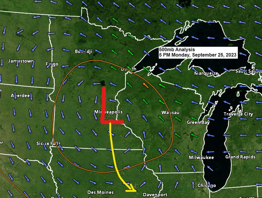
This system has been with us since late last week (Friday to be exact) and it continues to impact the Northland today, but the mid to upper-level low has moved from western Minnesota to southern Minnesota between Sunday afternoon and this afternoon, and on Tuesday will watch this low drop down into eastern Iowa and far enough away from the Northland which will end our rain chances.
Goes-16 water vapor loop from Monday, September 25, 2023 (loop time ends 4:01 PM CT)

The last of the rains hitting eastern Minnesota and northern Wisconsin this afternoon should come to an end before Midnight tonight, and then we’re looking at a couple of dry days, although an isolated shower still can’t completely be ruled out Tuesday or Wednesday, but most of us should stay dry.
NAM 3km model radar forecast through 7 AM Tuesday.

Thanks for reading!
Tim
Leave a Reply