6:15 PM Tuesday, October 3, 2023
After a few days of unseasonably warm temperatures, some changes will be taking place the next few days as an upper-level trough and cold front continue to move east out of the northern Plains and across the upper Midwest.
One cold front moves through the Northland late tonight-Wednesday morning which will be followed by a second cold front which moves through Wednesday night-Thursday morning and will also see an upper level low/trough dig SE into the area for Thursday and Friday.
The weather will be a bit unsettled at times with some showers through Friday due to the multiple fronts and troughs moving across the area but there should still be many dry hours mixed in.
As is often the case with these airmass changes during the fall, wind will be an issue the next few days with westerly winds gusting 20 to 30 mph at times Wednesday through Friday.
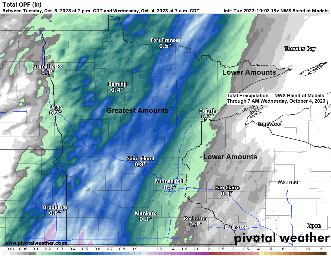
For Duluth: Some rain is possible tonight mainly after 9 PM and through the overnight followed by a few showers Wednesday and Thursday, and perhaps a steadier light rain for a few hours Friday morning into early Friday afternoon the way it looks now.
Rainfall amounts with tonight’s system look greatest across north central Minnesota with lesser amounts of rain expected in the Arrowhead, much of northwest Wisconsin and Twin Ports.
Temperatures will be on a downward trend starting on Wednesday with highs in the 60s to around 70 (warmest in northwest Wisconsin) which is still around to slightly above average for this time of the year, but even cooler temps will arrive for Thursday with highs in the 50s to lower 60s, and this cooling trend will likely peak Friday and Saturday with highs middle 40s to lower 50s.
***RECORD WARMTH IN THE NORTHLAND TODAY***
New daily record high temperatures were set for today, October 3rd.
Brainerd, MN: 84 (old record 83 set in 1913)
International Falls, MN: 84 (old record 82 set in 1922 and 2011)
Duluth, MN: 82 (old record 77 set in 1884, 1906 and 1913)
In addition to the record highs set today, we also set new record warm low temperatures at Duluth and International Falls on October 2nd, while Brainerd tied their record warm low temperature on October 2nd.

HRRR model radar forecast through 7 AM Wednesday.

Will see some strong lift and heavy downpours with embedded thunderstorms move across western, central and northern Minnesota with tonight’s system.
NAM model 500mb forecast through 7 AM Wednesday.

We’re already starting to see the effects of the changing airmasses today with temperatures running cooler compared to 24 hours ago in the blue and purple areas on the map below. This cooler airmass will continue to move farther east over the next 24 hours.

This likely will be the last time this year where we see 80+ degree temperatures in northeast Minnesota and northwest Wisconsin.
Note — Today marked the 40th day this year with a temperature of at least 80 degrees in Duluth. The average number of days with a temperature of at least 80 degrees in a year is 29 days.

Thanks for reading!
Tim
Leave a Reply