6:45 PM Tuesday, October 10, 2023
Rain and gusty northeast winds are possible across parts of the Northland late this week.
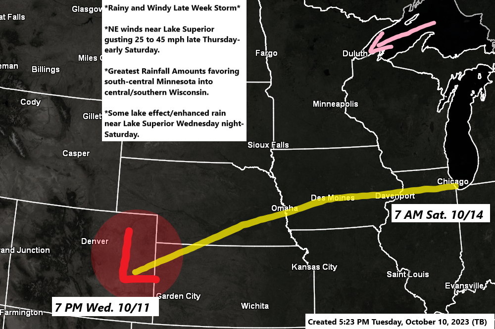
A strong area of low pressure is forecast to develop over eastern Colorado on Wednesday, this low is then forecast to move northeast or east-northeast as it passes near Chicago, Illinois Saturday morning.
On this track, the greatest amounts of rain would tend to favor the southern half of Minnesota into much of Wisconsin with lesser amounts of rain in far northern Wisconsin.
A sharp cutoff between measurable rain and no rain is expected to setup with this system (similar to a winter type system) and computer models disagree on where this cutoff zone between rain and no rain will be.
Strong northeast winds are possible near Lake Superior and Twin Ports area Thursday afternoon through at least Saturday morning with wind gusts of 25 to 45 mph possible with the strongest winds expected on Friday the way it looks now.
Lake effect and lake enhanced rain is also possible near Lake Superior beginning Wednesday night and continuing through Saturday as northeast winds cross Lake Superior with enough of a temperature difference in place to produce some lake effect rainfall.
For Duluth — A few lake effect rain showers are possible Wednesday afternoon through early Friday with a steadier rain associated with a Colorado low possible Friday into early Saturday. Greatest rainfall amounts with this late week system are expected south of the Twin Ports the way it looks now.
As I mentioned above, a sharp northern gradient in the rain is expected on Friday as drier air pushes south out of Ontario while moisture lifts north out of southern Minnesota and Wisconsin. Note — At the moment it looks like northern Minnesota could miss out on getting any rain with this system later this week.

*COMPUTER MODEL RAINFALL FORECASTS*
Computer models will continue to fine tune how far north the rain gets with this late week system.


*FLASH FLOOD POTENTIAL*
There is a potential for flash flooding on Friday especially in the yellow area on the map below.

*STRONG WINDS*
Here’s the European model wind gust forecast valid from 1 PM Thursday to 7 PM Saturday.

Still seeing a strong low-pressure system spinning over eastern Ontario today, or pretty much in the same location as it was 24 hours ago. Note — Will finally see this big low shift farther east over the next few days.
Goes-16 water vapor loop from Tuesday, October 10, 2023 (loop time ends 6:10 PM CT)

Note — We still haven’t officially seen our first 32-degree temperature of the season in Duluth (Airport location) with the lowest temperature so far this season of 33 on October 9th. The mean date for the first 32-degree temperature is October 1st (1874-2022 climate period), but just 2 years ago in 2021 the first 32-degree temperature didn’t occur until October 21st, and in 2019 it wasn’t until October 24th. The latest first 32-degree temperature on record for Duluth is November 1st set in 1900.
Thanks for reading!
Tim
Leave a Reply