6:41 PM Thursday, October 12, 2023
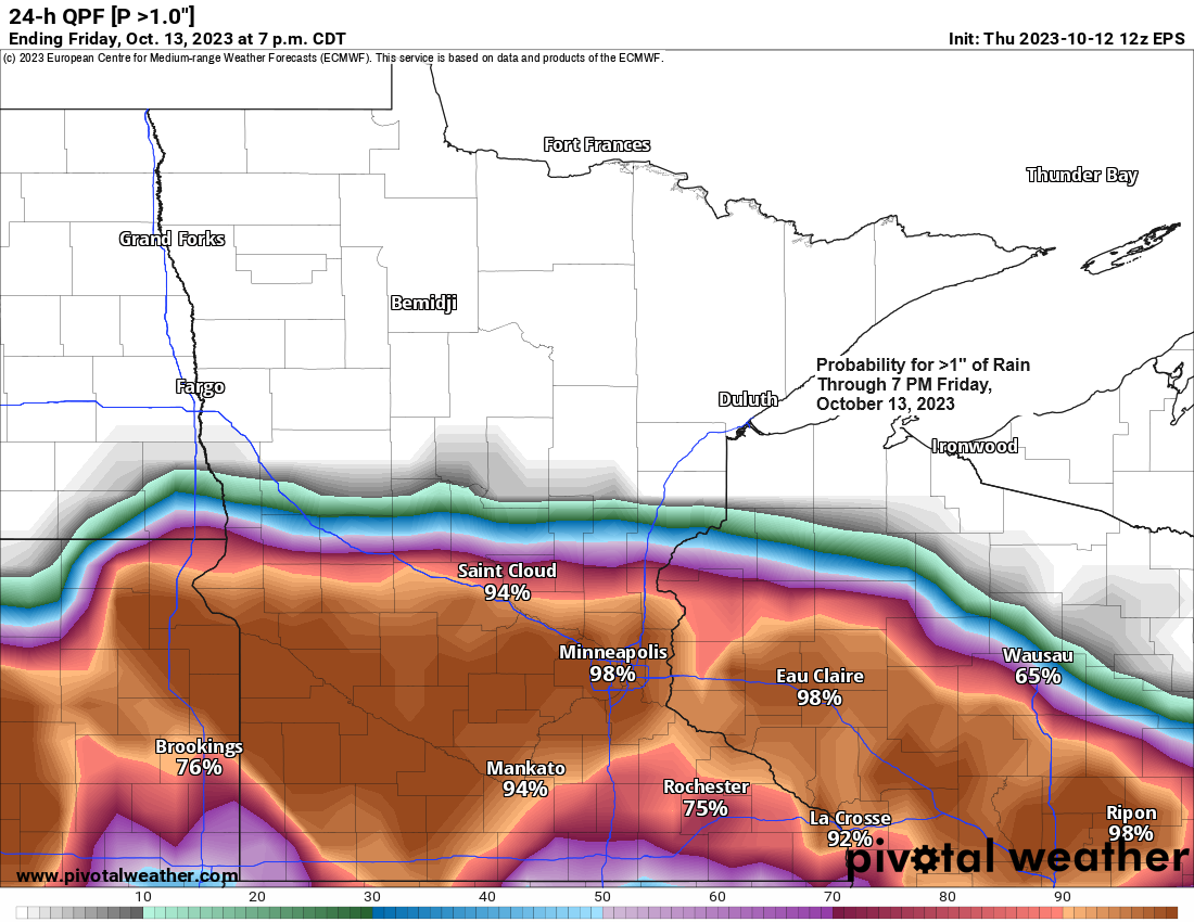
A strong area of low pressure over central Nebraska late this afternoon will be moving almost due east through Saturday morning. This low will pass near Omaha, Des Moines and Chicago through around daybreak on Saturday. On this track, the heaviest rain and greatest rainfall amounts will remain over the southern half of Minnesota into much of Wisconsin with lower rainfall amounts in far northern Wisconsin back to the Twin Ports area, while northern Minnesota and the Arrowhead miss out on getting any rain with this system on Friday.

It’ll take a while for the rain which is over southern Minnesota late this afternoon to spread north into east central Minnesota and northwest Wisconsin, but this should happen by late tonight or early Friday morning, while it takes even longer for this rain to reach the Twin Ports but that should happen sometime before Noon on Friday.
Radar loop from Thursday, October 12, 2023 (loop time ends 5:50 PM CT)

Dry air up north, moisture to the south. Northeast winds coming off Lake Superior along with drier air heading south out of Ontario will lead to a sharp gradient between rain and no rain across the Northland on Friday.

For Duluth — Looks like will eventually see some rain move into the city sometime around 9 AM to Noon Friday with rain tapering off to scattered showers Friday evening/overnight.
European model radar forecast through 7 AM Saturday.

Gale Warning for western Lake Superior Friday.

Lakeshore flooding possible from Friday morning through late Friday night from Canal Park to Bayfront Festival Park and areas in between within the city of Duluth.
-Large waves of 10 to 15 feet and prolonged gale force wind gusts out of the northeast will result in piling up of water in the Twin Ports area which may result in coastal flooding on Friday.
-Portions of Canal Park, Harbor Drive behind the DECC and Helberg Drive may become flooded.

Colder air to the north, warmer air to the south, a classic fall storm out there today.

Goes-16 water vapor loop from Thursday, October 12, 2023 (loop time ends 5:51 PM CT)

Strongest lift with the heaviest precipitation rates with this system will likely lift east-northeast out of southern Minnesota while passing south of Duluth through Friday.

Thanks for reading!
Tim
Leave a Reply