6:16 PM Friday, October 13, 2023
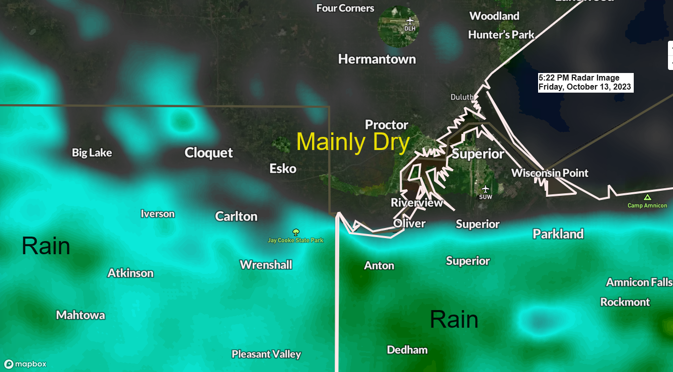
It’s been one of those days where the dry air and a big wind coming off Lake Superior helped to keep the rain away from the Twin Ports and all of northern Minnesota, North Shore and Arrowhead, and also in far northern Wisconsin (South Shore area) but you don’t have to travel very far south out of Duluth before you run into some rain, with locations from around Cloquet, Carlton and Wrenshall, to near Oliver, South Superior to Poplar seeing a little rain today with heavier rains a little further south from those locations.
As I pointed out a few days ago, there was a very sharp cutoff between rain and no rain today, and that cutoff ended up about 50 more miles to the south vs. what most of the computer models had been showing leading up to today’s rain event.
Note — Widespread rain continues late this afternoon from east central Minnesota into much of northwest Wisconsin, and this area of rain will slowly push toward the south/east and out of the areas affected by today’s rain by later tonight.
Radar loop from Friday, October 13, 2023 (loop time ends 5:22 PM CT)

Rainfall Reports for Friday, October 13, 2023 (thru 5:23 PM)
Source: MesoWest
Siren, WI: 0.84″
Shell Lake, WI: 0.83″
Spooner, WI: 0.78″
Webb Lake, WI: 0.72″
Hinckley, MN: 0.57″
McGregor, MN: 0.49″
Brainerd, MN: 0.43″
Hayward, WI: 0.39″
Minong, WI: 0.33″
Moose Lake, MN: 0.25″
Poplar, WI: 0.12″
Solon Springs, WI: 0.10″
Glidden, WI: 0.10″
Saginaw, MN: 0.09″
Clam Lake, WI: 0.09″
Hill City, MN: 0.06″
Washburn, WI: 0.03″
Esko, MN: 0.03″
Duluth Airport: 0.02″
Pine River, MN: 0.01″
Cass Lake, MN: 0.01″
Lots of moisture to the south today with quite a bit of dry air to the north.

Will see the widespread rain which affected east central Minnesota and northwest Wisconsin today continue into this evening, but this rain will taper off from NW-SE by late tonight.
A few showers will likely continue overnight and through the day Saturday in parts of the Northland.
HRRR model radar forecast through 7 PM Saturday.

Additional rainfall amounts through 7 PM Saturday, although the bulk of what is shown on the map below will fall tonight.

A strong area of low pressure centered between Des Moines and Davenport, Iowa late this afternoon will continue to move off to the east through Saturday.

An amplified weather pattern in place today with a strong ridge west of Hudson Bay Canada with a strong trough covering the upper Midwest.

A look at the large system across the Plains and Great Lakes today via visible satellite imagery. Loop time ends 4:55 PM CT, Friday, October 13, 2023.

And a look at today’s system on Goes-16 water vapor imagery — Loop time ends 5:46 PM CT, Friday, October 13, 2023.

Thanks for reading!
Tim
Leave a Reply