5:31 PM Tuesday, October 17, 2023
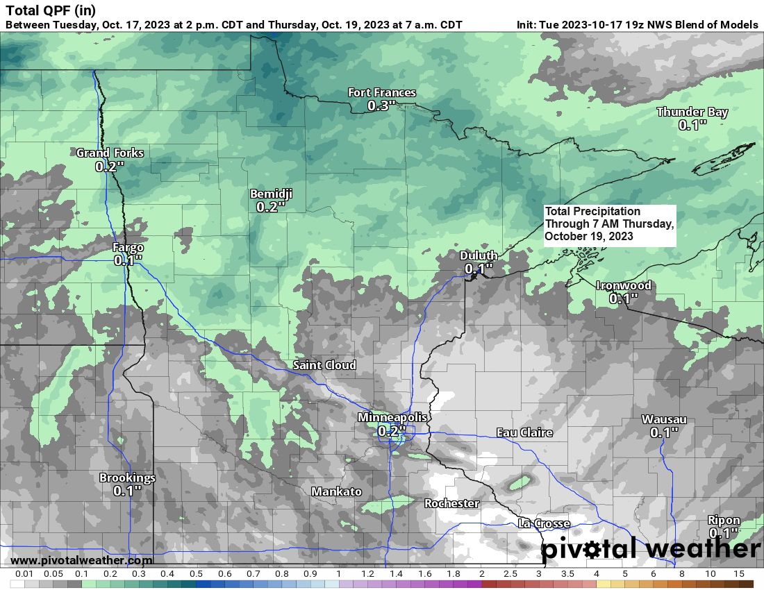
More rain is in the forecast across the Northland late tonight through the day Wednesday as a strong trough moves east-southeast out of the Northern Rockies.
Rainfall totals ranging from around 0.10″ to 0.40″ are likely in much of the Northland through Wednesday night.
Some more rain is possible on Friday as we see a clipper like system drop SE across the area.
Precipitation Anomalies for October 2023 (thru 4 PM on the 17th)
Ashland, WI: -1.37″ below normal
Duluth, MN: -1.31″ below normal
Hibbing, MN: -0.66″ below normal
Brainerd, MN: -0.21″ below normal
Rain late tonight and Wednesday shouldn’t be continuous with dry hours likely mixed in.
NAM 3km model radar forecast through 7 AM Thursday.


This is a pretty strong system which will be affecting the Northland over the next 24 hours, but it lacks moisture, so in the end we’re not looking at a widespread significant rain event in our area, but instead will likely be dealing with scattered rains at times late tonight into Wednesday.
Goes-16 water vapor loop from Tuesday, October 17, 2023 (loop time ends 4:30 PM CT)

Areas of rain over eastern Montana and North Dakota are east bound late this afternoon.
Radar loop ending 4:40 PM CT, Tuesday, October 17, 2023.

A very chilly start to the day in northeast Minnesota and northwest Wisconsin with widespread 20s and lower 30s.
*Duluth Airport had its first freeze of the season last night/early this morning with temperatures in the upper 20s. This is the first time since May 3rd, 2023, with a temperature at or lower than 32 degrees in Duluth.
Note — Last year’s first freeze in Duluth occurred on September 28th, the mean date for the first freeze is October 1st. The earliest first freeze on record for Duluth was on August 27, 1986, and the latest first freeze on record was on November 6th, 1900.
Low Temperature Reports from Tuesday, October 17, 2023
2 E Celina, MN: 22
Cotton, MN: 22
Embarrass, MN: 23
Hibbing, MN: 23
2 S Tower, MN: 24
Hayward, WI: 25
Ely, MN: 25
Cook, MN: 25
Crane Lake, MN: 25
Eveleth, MN: 25
Ashland, WI: 26
Superior Airport: 26
Solon Springs, WI: 27
Grand Marais Airport: 27
Longville, MN: 27
Aitkin, MN: 27
Cloquet, MN: 27
McGregor, MN: 28
Siren, WI: 28
Two Harbors, MN: 28
Bigfork, MN: 28
Grand Rapids, MN: 28
Butternut, WI: 29
4 W Clam Lake, WI: 29
Spooner, WI: 30
Duluth Sky Harbor Airport: 32

Temperatures warmed up quite a bit this afternoon with upper 50s and lower 60s common in northeast Minnesota and northwest Wisconsin, this is some +30 to around +35 degrees warmer compared to the temperatures we saw early this morning.

We could see a bit of a pattern change next week with a chance for an upper-level ridge to setup across the southern/eastern U.S., while a trough could setup across the western U.S. This may turn into an active pattern for the Northland next week with a few chances of precipitation which looks to mostly be in the form of rain.

Colder temperatures will also have a chance to push farther south/east out of western Canada and the Northern Rockies next week depending on how the overall pattern sets up, but for now it looks like will have temperatures which will be slightly above average in the Northland next week with the risk for temperatures to trend colder as the week goes on.

Here’s the GEFS model temperature anomaly trend for next week (October 23-28, 2023)
Oldest model run is Days 11-15.
Newest model run is Days 7-11.
Orange & Red colors: Warmer than average.
Blue colors: Colder than average.

Thanks for reading!
Tim
Leave a Reply