5:20 PM Wednesday, October 18, 2023
A strong surface and upper-level low is moving to the east-southeast across the upper Midwest this afternoon. This system brought some rain (mostly light amounts) to parts of northeast Minnesota and northwest Wisconsin today.
Some light rain will linger in parts of the Northland tonight (ending late), and then will see isolated to scattered coverage rain showers return on Thursday which will be followed by a stronger clipper type system Friday-early Saturday which looks to bring another round of showers to parts of the Northland along with some breezy conditions especially for western, central and southern Minnesota where wind gusts of 30-40+ mph are possible. Note — At the moment It doesn’t look as windy in the Northland on Friday due to our area being closer to where a surface low tracks.
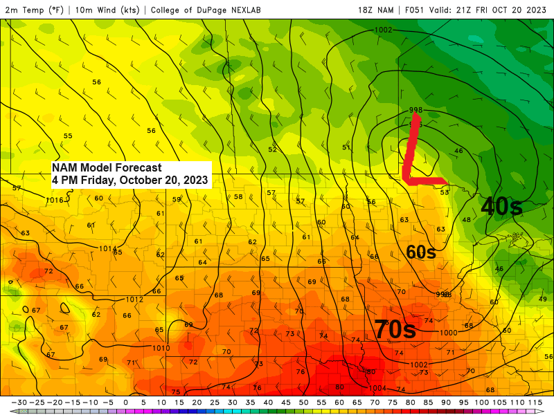
We could see quite a range in temperatures Friday afternoon depending on the track of this clipper system. 70s are possible in southwest Minnesota, while temperatures remain in the 40s in northeast Minnesota Friday afternoon.
Looking ahead to next week features a potentially active weather pattern with multiple chances for precipitation which looks to mostly be in the form of rain in northeast Minnesota and northwest Wisconsin, but there could be some snow late next week as colder air spreads east out of the Rockies and Northern Plains.
Here’s a look at the wind gust forecast for Friday (valid 7 AM to 7 PM)
Strongest winds across western, central and southern Minnesota on Friday.

Rainfall Reports for October 18, 2023 (thru 5:06 PM CT)
Source: MesoWest
Cass Lake, MN: 0.60″
Walker, MN: 0.44″
Deer River, MN: 0.37″
Northome, MN: 0.35″
Bigfork, MN: 0.28″
Hill City, MN: 0.26″
Grand Rapids, MN: 0.26″
Moose Lake, MN: 0.26″
Littlefork, MN: 0.26″
International Falls, MN: 0.25″
Brainerd, MN: 0.22″
Chisholm-Hibbing Airport: 0.21″
Saginaw, MN: 0.21″
McGregor, MN: 0.20″
Eveleth-Virginia Airport: 0.17″
Duluth Airport: 0.17″
Poplar, WI: 0.15″
Ashland, WI: 0.14″
Washburn, WI: 0.13″
Esko, MN: 0.12″
Nashwauk, MN: 0.11″
Cook, MN: 0.09″
Isabella, MN: 0.07″
Solon Springs, WI: 0.07″
Minong, WI: 0.05″
Hayward, WI: 0.05″
Duluth Sky Harbor Airport: 0.05″
Webb Lake, WI: 0.03″
The Bay of Grand Marais, MN: 0.02″
Ely, MN: 0.02″
Spooner, WI: 0.02″
Cable, WI: 0.01″
Clam Lake, WI: 0.01″
Rain over parts of northeast and east central Minnesota and northwest Wisconsin late this afternoon will gradually diminish from NW-SE tonight.
Radar loop ending 4:55 PM CT, Wednesday, October 18, 2023.

HRRR model radar forecast through 7 PM Thursday.

Low pressure over Minnesota this afternoon will be exiting off to the east by late tonight.

Here’s a look at today’s system on water vapor imagery. Certainly, a wound-up little system but it really hasn’t packed much of a punch today.
Goes-16 water vapor loop from Wednesday, October 18, 2023 (loop time ends 4:31 PM CT)

Here’s a look at how much additional rain we could see through around daybreak on Saturday.

Computer models continue to show a pattern change at least for a little while next week as a trough sets up over the western U.S., with a ridge across the south/east.
Currently it looks like the Northland will start next week with warmer than average temperatures, but eventually we may start to tap into a colder air mass which will be building off to our west, and this colder air may start to work its way into the Northland by late next week.

This is just a heads up as we could be seeing the first snows of the season sometime mid to late next week, but with this being about a week away, I’m pretty sure will see changes to snowfall amounts and the areas which could be seeing some snow next week. Stay tuned.
At the moment it looks like the highest snow amounts would be well west of the Northland next week with generally light snowfall amounts if we see anything at all in our area late next week.

Thanks for reading!
Tim
Leave a Reply