6:23 PM Monday, October 23, 2023
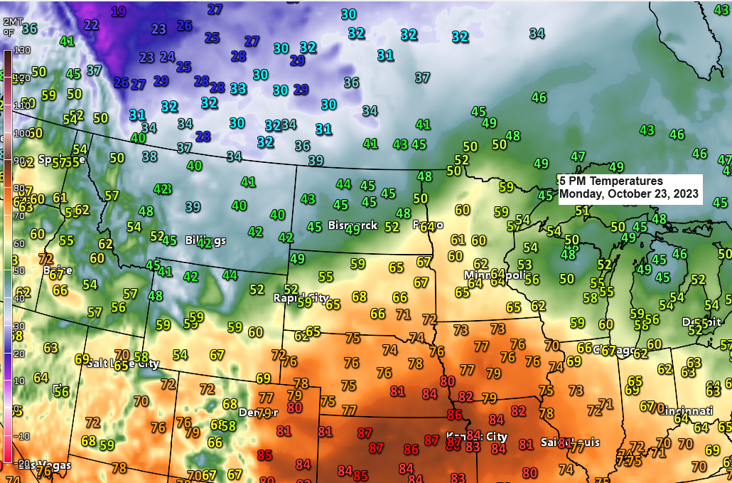
A mild day across northeast Minnesota and northwest Wisconsin today with highs in the mid 50s to low 60s which is about +10 degrees warmer than average for October 23rd.
Changes are coming, but they won’t happen right away.
A much colder air mass covering west central Canada and the northern Rockies today will spread farther south/east in the coming days, and this much colder air mass will finally reach the Northland late this week, most likely starting on Friday and then continuing into much of next week with highs only in the 30s with some locales up north possibly struggling to even reach 30 degrees on a few days this weekend/next week.

Far northern Minnesota will see some rain tonight through Tuesday morning, while occasional showers and thunderstorms occur farther south, from south central Minnesota into central Wisconsin from late tonight through early Wednesday.
Note — Duluth area should stay mainly dry tonight through Wednesday.
NAM 3km model radar forecast through 7 PM Wednesday.
Rain (green)
Snow (blue)

Total precipitation forecast through 7 PM Wednesday. Note — There are additional chances for precipitation late this week, and that’s when we could see some more precipitation in Duluth.

An unstable air mass over parts of the Central Plains today will spread northeastward into southern Minnesota and into much of Wisconsin at times through Thursday, and this should lead to the development of scattered thunderstorms from time to time over the next few days especially in the white outlined area on the map.

MID TO LATE WEEK SNOW CHANCES
First off, we won’t be seeing any snow in Duluth at least through Friday, and the most significant snowfall accumulations through Friday will be over western, central and northern parts of North Dakota where we could see 6 inches or more of snow, with much less snow if there’s any snow at all for far northern Minnesota including the International Falls area, and those snow chances aren’t until sometime late Thursday or Friday the way it looks now.

Rainfall Reports from Sunday night-Monday morning, October 22-23, 2023
Source: MesoWest
Moose Lake, MN: 0.17″
Minong, WI: 0.17″
Hinckley, MN: 0.17″
Siren, WI: 0.17″
Bigfork, MN: 0.17″
Saginaw, MN: 0.13″
Orr, MN: 0.12″
Deer River, MN: 0.11″
Esko, MN: 0.11″
Hill City, MN: 0.10″
Hayward, WI: 0.09″
Clam Lake, WI: 0.09″
Cass Lake, MN: 0.09″
McGregor, MN: 0.08″
Duluth Sky Harbor Airport: 0.08″
Solon Springs, WI: 0.08″
Grand Rapids, MN: 0.08″
Littlefork, MN: 0.07″
Poplar, WI: 0.07″
Walker, MN: 0.07″
Brainerd, MN: 0.07″
Hibbing, MN: 0.05″
Duluth Airport: 0.05″
Washburn, WI: 0.05″
Eveleth-Virginia, MN: 0.04″
Spooner, WI: 0.04″
Ashland, WI: 0.03″
Isabella, MN: 0.03″
Glidden, WI: 0.02″
The Bay of Grand Marais, MN: 0.02″
Thanks for reading!
Tim
Leave a Reply