6:38 PM Friday, October 27, 2023
And just like that the 2023-24 snow season gets underway across parts of the Northland today. A few inches of snow were reported in far northern Minnesota earlier today, while we’ve seen numerous scattered showers of snow and rain across other parts of the Northland this afternoon with even the first snow of the season occurring in Duluth both on top of the hill and below the hill this afternoon.
Remember how hot it was Labor Day weekend around here? 102 degrees in Brainerd, 97 degrees in Duluth and 95 degrees in Hibbing. I’m always fascinated how the atmosphere can undergo such a change from where it produces extremely warm temperatures in early September, to an atmosphere that becomes cold enough to produce snow in late October. Yes, it takes a while for those changes to occur, but still is pretty cool to watch it unfold.
Snowfall Reports from October 27, 2023
Source: National Weather Service Duluth, Minnesota
International Falls, MN 10.3 WSW: 2.9″
International Falls, MN 0.6 NW: 2.6″
Indus, MN: 2.5″
International Falls, MN 8.8 E: 1.8″
Big Falls, MN 1.0 N: 1.0″
Kabetogama, MN: 1.0″
Northome, MN 8.4 ESE: 0.5″
It has been a very wet fall in Duluth with numerous precipitation events since early September. Since September 1st, 38 days have had at least a trace of precipitation in Duluth, while just 19 days since September 1st have had no precipitation, but what’s interesting is that we’re actually running below average in precipitation this month in Duluth with a deficit of -1.17 inches through 4 PM on the 27th, but since September 1st Duluth has a precipitation surplus of +5.71 inches, all thanks to the extremely wet September we had.

Will continue to see a few snow showers and flurries pass through parts of the Northland at times tonight through Sunday, but it doesn’t look like will see much if any snow accumulation this weekend.
NAM 3km model radar forecast through 7 PM Sunday.

Snowfall forecast through 7 PM Sunday.

Pattern change is pretty much complete as a colder airmass continues to push into the Northland today behind an area of low pressure which has moved into eastern Canada this afternoon.
A broad upper-level trough covered the Rockies into the northern Plains today with a southwest flow aloft extending east into the upper Midwest.
500mb heights ranged from as low as 527 meters in the cold air in west central Canada this afternoon to as high as 591 meters in the very warm air across the southeast U.S.

Cold air is on the move! Temperatures late this afternoon ranged from the mid 30s in Minneapolis to the upper 60s in Chicago while widespread 70s and 80s covered the southern/eastern U.S. late today.

Goes-16 water vapor loop from Friday, October 27, 2023 (loop time ends 5:10 PM CT)

SNOW CHANCES EARLY NEXT WEEK
A vigorous upper-level low is forecast to move quickly south-southeast out of Manitoba on Monday, and this system could bring some light snow to parts of the Northland in the late Monday to Tuesday morning time frame with a chance for around an inch or so of accumulation depending on where the main band of snow sets up which is uncertain right now.

Here’s a look at the 500mb forecast and the track of that aforementioned upper low heading southeast out of Manitoba early next week via EPS model. Forecast is from Monday morning to Tuesday evening, October 30-31, 2023.

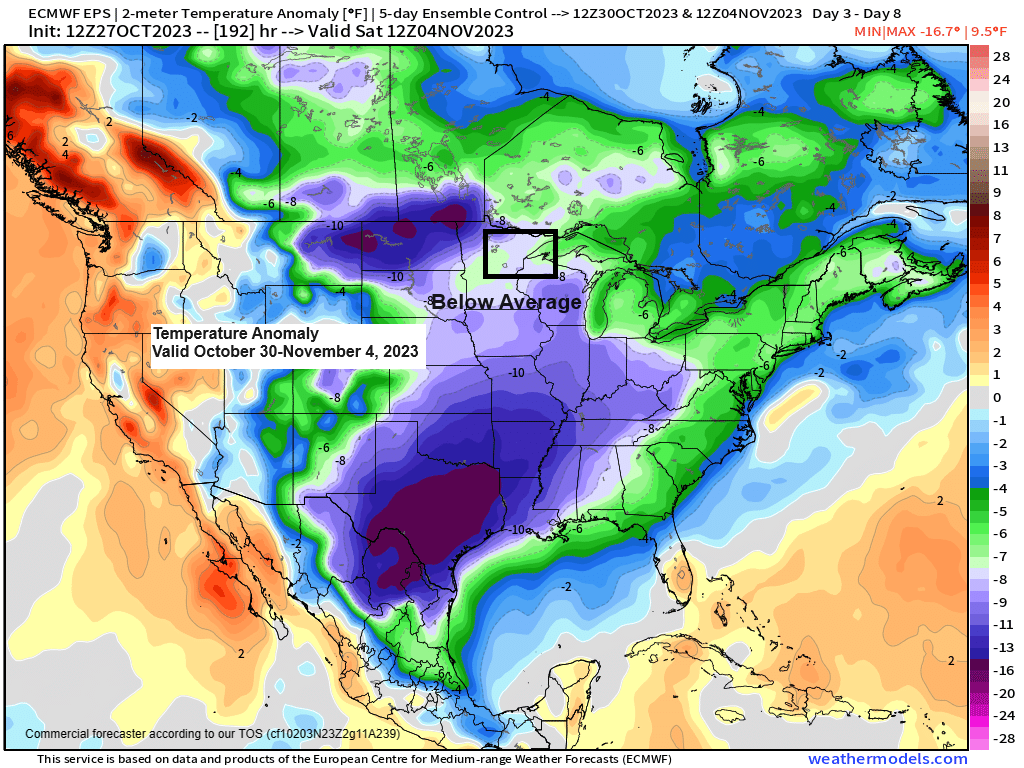
GEFS agrees nicely with the EPS model on keeping a chilly airmass in place well into next week.
Temperature Anomaly forecast valid October 30-November 4, 2023.
Oldest run is Days 8-12 on the loop below, and the newest run is Days 4-8.
Note — Below average temps in blue and purple colors.

Thanks for reading!
Tim
Leave a Reply