5:16 PM Monday, November 13, 2023
*No major rain or snow events impacting the Northland through Thanksgiving the way it looks now.
*Gusty southwest winds of 15 to 30 mph Tuesday with gusts to 45 mph possible.
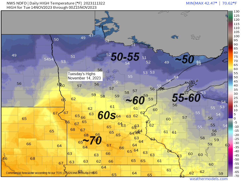
*Warmer Tuesday with highs in the 50s to lower 60s across the Northland.
*Late week cold frontal passage could bring a few snow showers/flurries to northern Minnesota late Thursday-early Friday, but no snow accumulation is expected.
*Temperatures although still slightly warmer than average do trend closer to normal late this week into early next week with a more significant shot of cold air possible around Thanksgiving. Note — Normal highs in Duluth are in the mid 30s from November 17-20 and normal lows during that same period are in the low 20s.
It was a ‘balmy’ mid-November afternoon across the Northland with temperatures ranging from the middle 40s in northern Minnesota to the 50s in eastern Minnesota and northwest Wisconsin with even warmer temps in the 60s farther south.
Note — Temperature at the Duluth Airport reached 51 degrees this afternoon (Nov. 13) this is the 1st official 50 in Duluth since October 24th when the temperature at the Airport reached 58 degrees.
-The average date for the last 50 in Duluth is November 9th (1991-2020 climate period) and on average we see 4 days in the 50s in Duluth during the month of November.
-In 2022, the last 50-degree temperature in Duluth occurred on November 26th. The latest last 50 on record occurred on December 22nd set in 1890.

Finally starting to see a more typical El Nino signature at least for now with below average temps confined to the deep south and also over parts of the northeast U.S., while a large area of above average temps covered the northern Plains and upper Midwest into the central Plains.

And the 500mb chart from today also reveals a more classic El Nino signature with the main storm track deflected well north of the upper Midwest, and also across the deep south while a big ridge covers the northern Plains and upper Midwest.

Goes-16 water vapor loop from Monday, November 13, 2023 (loop time ends 3:20 PM CT)

We do have some cooler risks showing up for a brief time late this week centered mostly on Friday-early Saturday, this is due to a fast-moving trough indicated by the blue and green colors on the map below, and this trough is forecast to move east out of the northern Rockies around midweek.

Here’s a look at the progression of a late week trough passing through the upper Midwest and Great Lakes late this week (blue and green colors on the animation below)
EPS model 500mb forecast valid from November 16-17, 2023.

Seeing a lot of volatility in the computer models this weekend and next week namely with the Euro model which had been showing a system lifting NE out of the Central Plains late this weekend/early next week, but now the Euro model is pretty similar to the GFS model in keeping that system on a much farther south track through the southern U.S. while we see another ridge develop across the northern Plains and upper Midwest this weekend into early next week. What this all means is that we could stay mostly dry across the Northland into early next week.

Potentially unsettled/stormy weather in blues and greens on the loop below while orange and red colors represent quieter weather/ridging.
500mb forecast via EPS model valid from November 19-21, 2023.

One thing the computer models do agree on is for a potentially more significant shot of cold air arriving in the Northland around Thanksgiving.

Thanks for reading!
Tim
Leave a Reply