6:23 PM Monday, November 20, 2023
A cold front will move across the Northland tonight and Tuesday morning before exiting to the east by Tuesday afternoon. We won’t be seeing a whole lot of precipitation as this front moves through tonight, but some light rain is likely in north central into northeast Minnesota tonight with the rain changing over to a little snow for a few hours early Tuesday morning with <1″ of snow accumulation. A little rain/snow is also expected in parts of northwest Wisconsin late tonight into Tuesday morning.
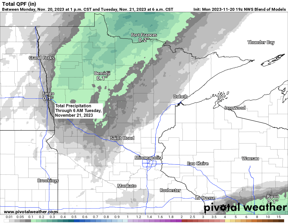
Duluth area: A little rain possible late tonight/early Tuesday morning. Rain could become mixed with snow mainly on top of the hill early Tuesday morning. Little if any snow accumulation is expected on top of the hill. Precipitation should come to an end before 6 AM Tuesday.
Note — Temperatures will turn a little cooler behind this 1st cold front with highs Tuesday in the 30s to around 40, but we will see another rebound in temps Wednesday especially across southern portions of the Northland where will see highs in the 40s on Wednesday with 30s across northern Minnesota. A stronger cold front will swing through on Wednesday and that front which will deliver a shot of much colder temps but only briefly with highs both Thanksgiving and Friday in the 20s to around 30, but when you compare these temps to what the averages are in late November, then this upcoming shot of cold air really isn’t very impressive. Temps rebound a little this weekend with afternoon temps climbing at or a little above freezing in parts of the Northland Saturday and Sunday.
Also of note is that it will be blustery the next few days with wind gusts of around 15 to 30 mph Tuesday and Wednesday.
NAM 3km model radar forecast through 12 PM Tuesday.
Rain (green)
Snow (blue)

Total precipitation forecast through 6 AM Tuesday.

I’m still not seeing any strong signals in model data for any big snows impacting our area through the end of this month and probably even into early December.
10-Day Snowfall Forecast thru November 30, 2023.

Only 9 Novembers dating back to 1885 produced less than 1″ of snow in Duluth. The most recent of them occurred in November of 1937.
Here’s the list of Novembers that had <1″ of snow in Duluth.
1937
1930
1928
1918
1917
1916
1913
1899
1888
With just 0.8″ of snow so far this month, will November 2023 join the aforementioned list? Time will tell.
Note — I should mention that snowfall records for Duluth prior to 1941 were taken at various locations closer to Lake Superior. It wasn’t until 1941 when snowfall records were taken at the Duluth Airport (on top of the hill in higher elevation)
Colder pattern remains on track late this week into early next week, although temperatures have trended a touch warmer compared to how things looked a few days ago for this same period.
EPS model forecast

GEFS model temperature anomaly forecast valid November 23-28, 2023.
Oldest model run is days 6-10 on the loop below, and the newest model run is days 4-8.
Blue colors=Below average temps

As we get into next week, we could see a milder pattern gradually redevelop/spread ESE out of the northern Rockies, but as is often the case in model land there is quite a bit of uncertainty on where temperatures go next week.
EPS model forecast.

GEFS model temperature anomaly forecast valid November 28-December 3, 2023.
Oldest model run on the loop below is days 11-15, and the newest model run is days 9-13.
Blue colors=Below average temps

Thanks for reading!
Tim
Leave a Reply