5:24 PM Sunday, November 26, 2023
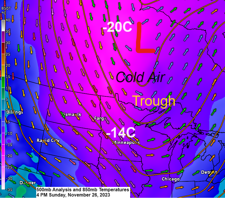
A quick shot of very cold air will drop south/east out of central Canada over the next 24 hours with 850mb temperatures across the Northland falling to around -20C on Monday, and this cold air will linger into Tuesday before we see some warmer air return mid to late week.
Coldest day this week will be on Monday with highs in the mid 10s to low 20s in the Northland, and we’re looking at temps in the single digits and 10s overnight tonight/Monday morning, and mainly in the single digits for Monday night/Tuesday morning with a chance for a few subzero temps up north.
This cold air will shift farther east by Wednesday with temps by Wednesday afternoon climbing well into the 30s to around 40 degrees across the Northland.
0.2 inches of snow in Duluth today. Total snowfall for November is up to 1″ which is nearly -11″ below normal to date and is just ~9% of our normal snowfall to date. Note — It doesn’t look like will be getting much more snow in Duluth the rest of this month, but November 2023 won’t end up the least snowy November on record as that honor goes to November 1928 and November 1913 with both only recording a trace of snow the entire month.
Late Sunday afternoon temperatures.
Lots of cold air up north spreading south/east over the next 24 hours.

With plenty of cold air crossing the warmer waters of Lake Superior this will cause lake effect snow showers which could be heavy at times tonight through Monday night in the NW wind favored areas which would include the South Shore of Lake Superior in northern Wisconsin and upper Michigan.
There will also be some lake effect snow showers coming off some of the larger inland lakes across northern Minnesota tonight and Monday.
Elsewhere away from the lake effect snows, will see snow showers and flurries gradually diminish tonight.
NAM 3km model radar forecast through 6 PM Monday.

Snowfall forecast through late Monday night.

Pattern this week will feature a deep trough east of the Northland with a ridge over western Canada and Pacific northwest. Note — This isn’t the type of pattern you want to see if you like a lot of snow in the Northland. In fact, the week ahead is looking pretty quiet/dry outside of a few snow showers and flurries.
EPS model 500mb forecast for November 27-December 2, 2023.

This week starts cold across the Northland, but warmer air is forecast to move in mid to late week.

GEFS model temperature anomaly forecast for November 27-December 2, 2023.
Oldest model run is days 4-8 on the loop below and the newest model run is days 2-6.
Below average temps in blue colors
Above average temps in orange and red colors

Temperature trends for December 3-8 features widespread above average temps at the moment.
EPS model temperature anomaly forecast for December 3-8, 2023.

GEFS model temperature anomaly forecast for December 3-8, 2023.
Oldest model run is days 10-14 on the loop below and the newest model run is days 8-12.

Thanks for reading!
Tim
Leave a Reply