6:24 PM Thursday, December 7, 2023
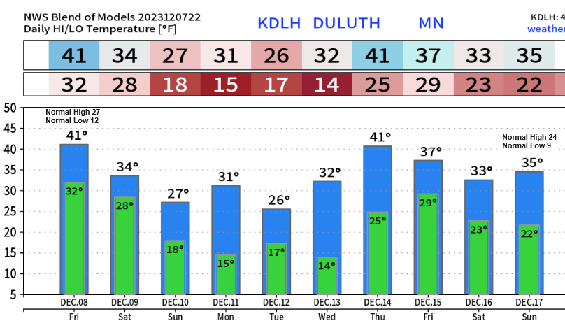
Note — No subzero nights so far this month in Duluth, and none are in the forecast at least through December 17th. The average number of subzero nights in Duluth during the month of December is 8.
Here’s the list of years where Duluth didn’t have any subzero nights in December.
2015
1959
1918
1913
1888
1877
We have another mild day ahead for Friday with highs in northeast Minnesota and northwest Wisconsin in the 40s with a few 50s possible in northwest Wisconsin.
Here are the record highs for December 8th
Ashland, WI: 58 set in 1939
Brainerd, MN: 52 set in 1939
Duluth, MN: 45 set in 1990
Hibbing, MN: 45 set in 1990
International Falls, MN: 45 set in 1990
Temperatures do cool down a bit this weekend/early next week, but temperatures will really just be a little closer to normal for this time of the year, but warmer temperatures look to return again mid to late next week.

One location in the Northland tied its daily record high temperature today, otherwise high temperatures fell short of the record highs on today’s date, but highs today were still around +20 degrees above average for December 7th.
High Temperature Reports from today, Thursday, December 7, 2023
Ashland, WI: 49 (record high 53 set in 1939)
Brainerd, MN: 48 (record high 53 set in 1939)
Duluth, MN: 46 (record high 51 set in 1939)
Hibbing, MN: 46 (record high 51 set in 1939)
International Falls, MN: 46 (tied the record high for today’s date which was 1st set in 1918)
A strong ridge has moved over the upper Midwest today with very warm temperatures at 850mb (~5000 feet in the atmosphere) ranging from +8 to +15C today.

24-Hour loop of locations which tied or broke their daily record high temperature ending 4 PM CT, Thursday, December 7, 2023.
Orange=Record high tied
Red=Record high broken

A little Saturday SNOW?
We could see a little snow move across the Northland on Saturday, but accumulations look to stay under an inch, but with temps in the upper 20s and lower 30s, this little amount of snow could still cause some slick spots on area roads.
NAM 3km model radar forecast valid 6 PM Friday to 6 PM Saturday.

Eastern North Dakota to northeast South Dakota into northwest Minnesota could see around 1 to 3 inches of snow Friday-early Saturday with lesser amounts of snow expected farther east on Saturday.

More uneventful weather for next week across the Northland with a NW flow aloft in place along with a strong ridge off to our west.

Computer models continue to be in good agreement regarding the temperature trends for next week, and it looks like more of the same for the Northland with another week of above average temperatures expected.
EPS model temperature anomaly forecast for December 11-16, 2023.

GEFS model temperature anomaly forecast for December 11-16, 2023.
Oldest model run is days 7-11 on the loop below and the newest model run is days 5-9.
Orange and red colors: Above average temperatures
Blue colors: Below average temperatures

Thanks for reading!
Tim
Leave a Reply