5:08 PM Wednesday, December 6, 2023
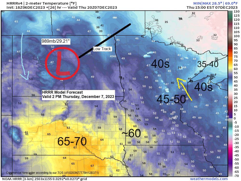
A strong area of low pressure will lift northeast across North Dakota on Thursday and with this low passing west of our area this will keep the Northland in a milder southerly flow with highs in the 40s on Thursday, but a few 50s are possible around Brainerd, Hinckley and Siren,
High temperature reports from today, Wednesday, December 6, 2023
Note — Today’s highs in the Northland were about +10 degrees warmer than average for December 6, except for International Falls which had a high temperature +20 degrees warmer than average today.
International Falls, MN: 44 (record high 45 set in 2015)
Brainerd, MN: 41 (record high 61 set in 1939)
Ashland, WI: 40 (record high 57 set in 1939)
Duluth, MN: 35 (record high 56 set in 1939)
Hibbing, MN: 35 (record high 58 set in 1939)
A very mild air mass (more typical of late summer) will remain over the area on Thursday with 850mb temperatures ranging from around +8C in northeast Minnesota to as warm as +13C over southwest Minnesota, but with it being early December when the sun angle is so low, plus the short days, this will keep temperatures from getting too warm on Thursday, but we’re still looking at highs in the 40s in the Northland with 50s and 60s in southern Minnesota.
Record Highs for December 7
Ashland, WI: 53 set in 1939
Brainerd, MN: 53 set in 1939
Duluth, MN: 51 set in 1939
Hibbing, MN: 51 set in 1939
International Falls, MN: 46 set in 1918

A strong upper-level ridge covered areas from the Rockies to the northern and central Plains today with a lot of warm air for this time of the year under that ridge, while two troughs associated with a colder air mass were found over the eastern U.S., and also over western Canada into the Pacific northwest late today.

The potential for a winter storm well southeast of the Northland this weekend has diminished quite a bit over the last day or so as will see two troughs, one to the north and another trough to the south remain separate instead of phasing into one big trough which would’ve led to a stronger surface low lifting northeast out of the southern Plains this weekend.
The northern trough pushing east across the area on Saturday could lead to some light snow in parts of the Northland with a chance for a little snow accumulation ranging from a trace to 2 inches, with the greatest chances for up to 2 inches of snow Saturday centered on parts of northern Wisconsin the way it looks now.

Two troughs on Saturday but they don’t really phase until they get well east of the Northland.

The trough lifting northeast out of the southern Plains this weekend will be deepening as noted by the green colors on the loop below, but the southern trough really won’t be impacting the Northland.
EPS model 500mb forecast valid Friday, December 9, to Monday, December 11, 2023.

NEXT WEEK’S TEMPERATURE TRENDS
Early next week has trended a little cooler across the Northland, but milder air builds back in for mid to late next week with the greatest departures from normal coming mid to late next week, so overall we’re looking at above average temperatures once again in the Northland next week.
EPS model temperature anomaly forecast valid December 11-16, 2023.

GEFS model temperature anomaly forecast valid December 11-16, 2023.
Oldest model run is days 8-12 on the loop below and the newest model run is days 6-10.
Orange and red colors: Above average temperatures
Blue colors: Below average temperatures

Thanks for reading!
Tim
Leave a Reply