6:07 PM Saturday, December 9, 2023
Strong northwest winds of 15 to 30 mph will continue across the Northland tonight with even stronger winds near Lake Superior especially along the North Shore where wind gusts could reach 50 mph. Winds will diminish significantly on Sunday.
Cooler temperatures are moving in behind today’s system with lows tonight in the teens and lower 20s, with single digits and teens likely for Sunday night, Monday night and Tuesday night.
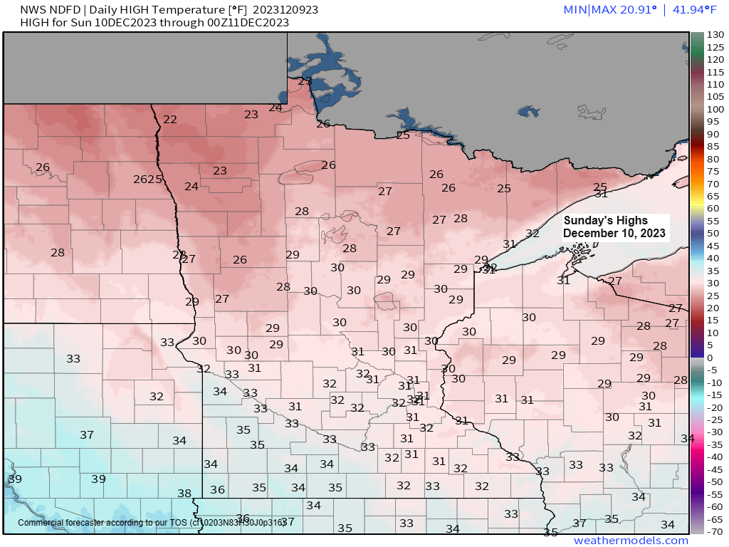
Highs Sunday will be in the mid 20s to around 30 with highs Monday in the low to mid 30s. Cools down again Tuesday with highs in the 20s, but this will be followed by a warming trend mid to late next week with highs in the 30s and 40s.
Not looking at a whole lot of precipitation in our area next week.
Note — 0.7 inches of snow was reported at the NWS in Duluth through 4 PM today. Monthly snowfall total is up to 1.4 inches which is -3.9 inches below normal to date and is just 26% of our normal monthly snowfall to date.
A strong mid and upper-level low pressure system moved east across the Northland today and this low was centered over north central Wisconsin as of early this evening.
This system brought some snow and rain along with falling temperatures and increasing northwest winds to the Northland today.

Quite an impressive system over the upper Midwest today.
Goes-16 enhanced satellite loop from Saturday, December 9, 2023 (loop time ends 5:06 PM CT)

Snow showers over northeast Minnesota will end this evening while snow showers continue much of the night along the South Shore of Lake Superior in northwest Wisconsin, but away from the South Shore the snow showers will end by late tonight.

NAM 3km model radar forecast through 6 AM Sunday.

Snowfall forecast through 6 AM Sunday.
South Shore of Lake Superior in northern Wisconsin will see most of the snow tonight with accumulations ranging from 2 to 5 inches around Hurley and Gile, to around 1-2 inches farther west along the South Shore.

The other big weather story on this Saturday has been the severe weather which has impacted portions of the Tennessee and Lower Mississippi Valleys.
Goes-16 sandwich satellite loop ending 5:11 PM CT, Saturday, December 9, 2023.

Tornado watches are in effect through this evening (red areas on the map below)

Here’s what the radar looked like at 4:43 PM today as tornado warned storms impacted areas north of Nashville, TN.

And a look at the volumetric radar (3d) from late Saturday afternoon on one of the tornado emergency warned storms near Gallatin, TN.

One-Hour rotation tracks and tornado reports from late Saturday afternoon.
Note — There’s been 13 preliminary reports of tornadoes in Kentucky and Tennessee today per SPC storm reports page.

Thanks for reading!
Tim
Leave a Reply