6:39 PM Friday, December 22, 2023
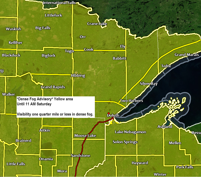
Light winds, mild temperatures and a very humid airmass (for this time of the year) have led to the development of widespread fog in the Northland and other parts of the upper Midwest today, and this fog will persist through the night and into Saturday morning with visibility of one quarter mile or less.

Fog should stick around into Saturday morning, but the fog may lift leading to better visibility in parts of the Northland Saturday afternoon, but more fog is expected Saturday night into Sunday morning.
HRRR model visibility forecast through 5 PM Saturday.

An active weather pattern is on the way as we get into Christmas Eve and then continuing into the middle of next week as we see a pair of upper-level lows and troughs move across the Rockies and into the Plains.
Models today have been trending toward more phasing of the two systems by early next week with a chance that we may even see a negatively tilted trough develop early next week across the upper Midwest and central Plains. What this all means is that we may see a fairly strong system impact the Northland with a variety of precipitation types late this weekend into early next week. A period of gusty winds out of the northeast are also possible especially near Lake Superior early next week.

Some patchy drizzle is likely in the Northland tonight and Saturday, followed by steadier and somewhat heavier precipitation which overspreads the Northland from southwest to northeast late Saturday night and through the day Sunday.
Euro model precipitation type forecast valid 6 PM Saturday to 6 PM Sunday.
Rain (green)
Snow (blue)
Wintry Mix (pink/orange)

One round of precipitation is likely in the Northland Sunday into Sunday night followed by another round of precipitation from Monday into late Tuesday, so in the end we could be looking at a fairly significant precipitation event across the Northland with totals of 0.50″ to 1.00″+ by the middle of next week.

SNOWFALL POTENTIAL CHRISTMAS EVE
Far northwest portions of the Northland could see rain change to a few hours of wet sloppy snow Sunday afternoon or Sunday evening with snowfall accumulations of a trace to 2 inches possible.

FREEZING RAIN/ICE POTENTIAL EARLY NEXT WEEK
The potential for some freezing rain is increasing in parts of the Northland early next week with a chance for ice accumulations of >0.05″ from Monday evening through Tuesday.
Here are a few different computer model ice accumulation forecasts.
NWS Blend of Models

European model which shows a fairly significant amount of ice across northern Minnesota early next week.

And finally, here’s the Euro ensemble (EPS model) forecast which shows the low end and high-end ice accumulation amounts.

Thanks for reading!
Tim
Leave a Reply