6:40 PM Saturday, December 23, 2023
A slow-moving wet system will impact the Northland starting late tonight or Sunday morning, and then continuing through Tuesday with some lingering effects still possible all the way to next Wednesday.
The heaviest precipitation rates are expected in two waves, one on Sunday (Christmas Eve), and then again sometime Monday (Christmas Day/Night). In between these waves of heavier precipitation, will likely see lighter precipitation rates which could continue all the way into Tuesday or even Wednesday.
By Tuesday evening, much of the Northland could get between 1 and 2 inches of precipitation so this will indeed be a very wet system. Note — Just for fun, if all this precipitation fell as snow in Duluth, then we’d be looking at upwards of 2 feet of snow by Tuesday, but that won’t be the case with this event, in fact it doesn’t look like will be seeing any snow in Duluth through Tuesday, with mostly rain expected.
NWS Blend of Models total precipitation through 6 PM Tuesday.

Duluth area: Rain begins late tonight (after Midnight) with a rainy Christmas Eve likely although some breaks in the rain are possible during the day. More rain Sunday night.
Parts of northern Minnesota (west/north of Duluth) could see the rain mix with or change to some snow Sunday night with <1″ of snow expected.
NAM 3km model radar forecast valid from Midnight tonight to 6 AM Monday.
Rain (green)
Snow (blue)
Wintry Mix (pink)

FREEZING RAIN POTENTIAL
There is a chance for some freezing rain in parts of northern and northeast Minnesota Christmas Day with ice accumulations <0.10 inches.
Far northern Minnesota could also see some freezing rain late Monday night or Tuesday.
Currently it looks like the highest potential for freezing rain with some ice accumulation will be west and north of Duluth Monday and Tuesday.

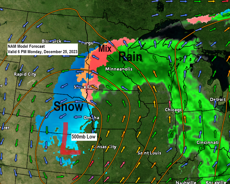
Parts of South Dakota, Nebraska and Kansas will likely see the greatest snowfall accumulations with this upcoming system with the heaviest snowfall rates expected Christmas Day into Tuesday morning.

This will be an odd storm track as low pressure over northern Missouri Christmas morning lifts northwest reaching eastern Nebraska by Tuesday morning.
With the low staying south of Lake Superior and with a strong area of high pressure north of Lake Superior, this pressure difference between the low and high will cause gusty northeast winds near Lake Superior Monday into Tuesday morning.

Our system is coming together and slowly approaching from the southwest this evening.
Goes-16 water vapor loop ending 6 PM Saturday, December 23, 2023.

Again, this will be a slow-moving system as it moves out of the Northern Rockies Sunday morning, while not reaching the Ohio Valley until late Wednesday or Thursday morning.
EPS model 500mb forecast valid from 6 AM Sunday to 6 AM Thursday.

Widespread dense fog with visibilities <1/4 mile will linger into early Sunday morning along the North Shore of Lake Superior.
Patchy fog is also possible over the rest of the Northland tonight and Sunday, but widespread dense fog is not expected.

Note — Ashland tied its record high temperature today with a high of 46. This ties the record high for December 23, and this record was first set in 1931.
***RECORD HIGHS FOR DECEMBER 24***
Ashland: 53 set in 1923
Duluth: 47 set in 1881
Brainerd: 45 set in 1899 and 1994
Hibbing: 44 set in 1994
International Falls: 42 set in 1994
Record or near record warmth is possible in the Northland on Christmas Eve.

Highs on Sunday will be running +20 to nearly +30 degrees above normal in the Northland.

Thanks for reading!
Tim
Leave a Reply