10:09 AM Sunday, December 24, 2023
Merry Christmas Eve!
We’ve got quite a storm on the way, but this won’t be your typical late December storm we see in the Northland as we’re looking at mostly rain in Duluth and northwest Wisconsin, while the potential for freezing rain and ice accumulations increases across northern Minnesota into the Arrowhead for Monday into Tuesday.
Very strong northeast winds are also expected near Lake Superior including in the Twin Ports Monday afternoon through Tuesday with wind gusts of 30 to 55 mph possible.
Rainfall totals so far (through 10:03 AM Sunday)
Source: MesoWest
Hill City, MN: 0.60″
Brainerd, MN: 0.52″
Hermantown, MN: 0.31″
International Falls, MN: 0.30″
Saginaw, MN: 0.29″
Esko, MN: 0.28″
Hibbing, MN: 0.28″
Grand Rapids, MN: 0.27″
Duluth Airport: 0.24″
Moose Lake, MN: 0.24″
Walker, MN: 0.18″
McGregor, MN: 0.14″
Duluth Sky Harbor Airport: 0.03″
For today (Sunday) the most persistent and heaviest rain is forecast to fall across portions of east central into northern Minnesota with Duluth will be on the eastern edge of this more persistent rain through much of the day, while most of northwest Wisconsin stays dry except in the far northwest part where some rain showers are likely today.
Total precipitation through 6 PM Sunday.

But as we get into tonight rain will become more widespread in all of northwest Wisconsin while rain continues in northeast Minnesota.
More precipitation is likely for Monday and Tuesday.
Note — It still looks like we could see precipitation totals of around 2 inches in Duluth by Wednesday morning, and almost all of this precipitation will likely be in the form of rain (no freezing rain/icing)
Total Precipitation through 6 AM Wednesday.

***FREEZING RAIN/ICE POTENTIAL***
Northern Minnesota into the Arrowhead could see some freezing rain develop on Monday, and this potential for freezing rain will spread farther north to the International Falls area by late Monday night or during the day Tuesday. Ice accumulations of 0.05″ to 0.10″ or more are possible in northern Minnesota and Arrowhead from Monday into Tuesday.
Note — I still think the greatest potential for freezing rain will be north of Duluth Monday and Tuesday.

***STRONG WINDS/GALES ON LAKE SUPERIOR***
Strongest winds (NE direction) are expected Monday afternoon through Tuesday in the Twin Ports area and near Lake Superior.
NAM 3km model wind gust forecast valid 6 AM Monday to 6 PM Tuesday.

Gales on western Lake Superior with waves of 10 to 14 feet Monday afternoon into Tuesday.
Lakeshore Flood Potential is around 25% per NWS update Sunday morning.

European model precipitation type forecasts for the times indicated on the images below.
Rain (green)
Snow (blue)
Wintry Mix (pink)


And here’s the forecast radar loop from the European model through 6 PM Tuesday.

***RECORD WARMTH IN THE NORTHLAND TODAY***
We’ve already seen a few new record highs set in the Northland today and its only 9 AM as of the writing of this post.
Brainerd: 48 so far (old record for 12/24, 45 set in 1994)
International Falls: 43 so far (old record 42 set in 1994)
Other record highs to keep an eye on for today.
Ashland: 53 set in 1923
Duluth: 47 set in 1881 (142 years ago)
Hibbing: 44 set in 1994

Crazy warm for late December around here with temperatures at 8:30 AM this morning running +30 to +35 degrees warmer than normal.

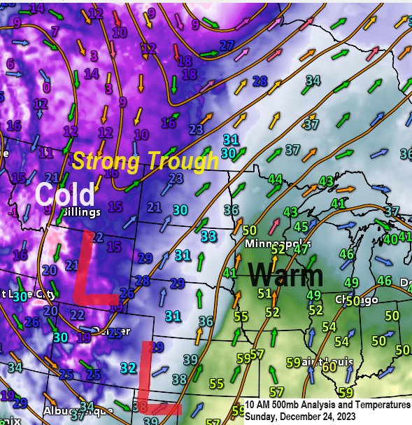
***POWERFUL WINTER STORM LATE TONIGHT THROUGH LATE TUESDAY NIGHT***
Blizzard warnings have been issued for much of central and northern Nebraska into parts of southern South Dakota ahead of this approaching winter storm.

Forecast snowfall storm totals through 6 AM Wednesday via NWS Blend of Models.

And here’s a zoomed-out view of forecasted snowfall totals through 6 AM Wednesday via NWS Blend of Models.

Thanks for reading!
Tim
Leave a Reply