6:37 PM Thursday, December 28, 2023
- Areas of fog and some freezing fog impacting parts of the Northland tonight and Friday.
- Light snow with scattered heavier snow showers Saturday-Sunday morning.
- Slightly cooler but still above normal temperatures this weekend into next week.
- Pattern change (albeit a slow one) possible beginning late next week?
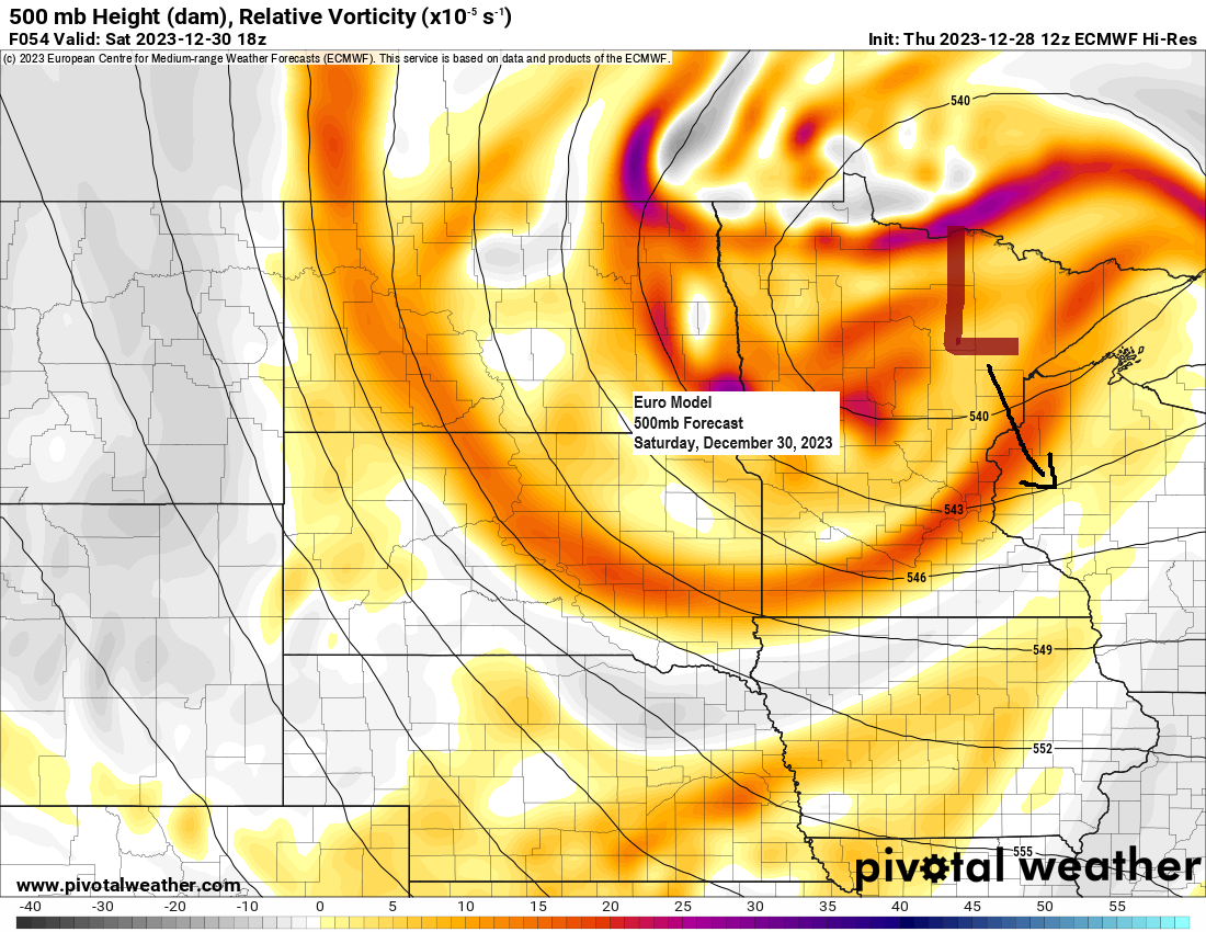
An area of low pressure centered over central Saskatchewan this evening will track southeast reaching north central Wisconsin by Saturday evening. A cold front connected to this low will pass through the Northland late Friday night or Saturday morning. This system will likely produce a little snow across the area Saturday into Sunday morning with accumulations of a trace to 1″, but some lake effect snow is expected to develop along the South Shore of Lake Superior late Saturday night into Sunday with up to 3 inches of snow possible around the Hurley and Gile areas in Iron County.
European model 500mb forecast valid 6 AM Saturday to 6 AM Sunday.

Duluth area: Light snow and snow showers at times especially from Saturday afternoon or Saturday evening into early Sunday morning with up to 1″ of snow possible. Temperatures in the upper 20s to around 30 Saturday afternoon, falling into the lower 20s Sunday morning.
European model radar forecast valid 6 AM Saturday to 6 AM Sunday.

Forecast snowfall totals this weekend via NWS Blend of Models.

Areas of fog (some freezing fog) are likely in parts of the Northland tonight into Friday with visibility around 1 mile or less in the darker colored areas on the loop below.
HRRR model visibility forecast through 6 PM Friday.

Low clouds and fog show up in white on the loop below.
Goes-16 microphysics satellite loop from Thursday, December 28, 2023 (loop time ends 5:16 PM CT)

A large upper-level low pressure system continues to move slowly east across the Midwest and southern Great Lakes today with some rain and snow, but fortunately this system is far enough away from the Northland to produce any additional precipitation in our area today, but fog and some freezing fog has been an issue in parts of northwest Minnesota today due to abundant moisture and light winds which is trapped near an upper-level ridge over the northern Plains.
850mb temperatures ranged from around +9C in southern Manitoba to -5C in southern Missouri, so once again we’re seeing a milder airmass to the north while a cooler airmass covered areas farther south today.

Goes-16 water vapor loop ending 5:10 PM CT, Thursday, December 28, 2023.

No major storm systems will be impacting the Northland at least through the middle of next week.
EPS model 500mb forecast valid December 29 to January 3.

But as we get into late next week and beyond, we could be seeing quite a shift in the pattern, and its one that could start to bring more frequent shots of colder temperatures/perhaps arctic air to the Northland with time, along with some snow chances (something other than minor snow events)
EPS model 500mb forecast valid January 5-10.

There are some signals showing up in the computer models for a system to come out of the Rockies sometime in the January 6-10 time frame.
GEFS model snowfall forecast through January 13, 2024.
Purple colors on the images below represent snow totals of 6″+ using a 10:1 ratio.

A lack of arctic air through next week, although temperatures will be turning cooler compared to where they’ve been this week, but the temperatures next week will still be running above normal in our area for early January.
EPS model temperature anomaly forecast valid January 1-6, 2024.
Above normal temperatures in orange and red.
Below normal temperatures in blues.

GEFS model temperature anomaly trend for January 1-6, 2024.
Oldest model run is days 7-11 on the loop below and the newest model run is days 5-9.
Above normal temperatures in orange and reds.
Below normal temperatures in blue colors.

Thanks for reading!
Tim
Leave a Reply