6:08 PM Monday, January 15, 2024
- 4 subzero nights so far this month in Duluth. Average number of subzero nights in January is 14.
- 16.6 inches of snow so far this season in Duluth. Normal snowfall to date is 44.1 inches. Departure of -27.5 inches below normal to date. By this time last year, 70 inches of snow had fallen in Duluth.
- Lake effect snow showers along the South Shore mainly affecting northern Bayfield County including Port Wing, Herbster, Cornucopia, Red Cliff and Bayfield through Wednesday morning.
- A few flurries/snow showers possible elsewhere in the Northland through Tuesday night.
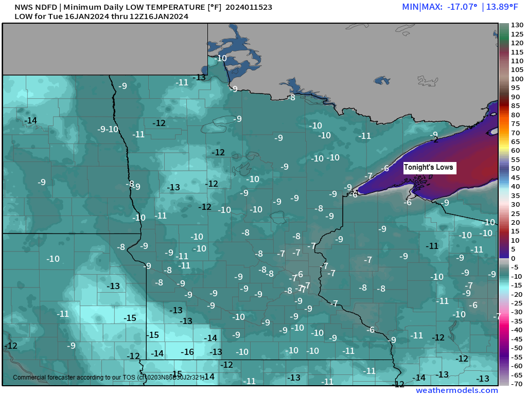
Another cold night ahead with lows ranging from around 5 below to 15 below in the Northland, and highs on Tuesday will range from around zero to 5 above. Will finally get rid of this arctic air, but not until Sunday.

Wind Chill Advisory continues until Noon Tuesday for all of northeast Minnesota and northwest Wisconsin. Wind chills as low as 30 to 35 below zero. Note: Additional wind chill headlines may be needed mid to late week.
There’s also a winter weather advisory (purple area on map) in effect until Midnight Tuesday night for Bayfield County in Wisconsin.

Yes, it’s cold, but our low temperatures at least here in the Northland aren’t even close to what our record low temperatures are for mid-January. See below.
Low Temperature Reports from Monday morning, and the record lows for January 15.
Source: National Weather Service Duluth, Minnesota
International Falls, MN: -17 (Record low -45 set in 1909 and 1972)
Hibbing, MN: -16 (Record low -41 set in 1972)
Duluth Airport: -14 (Record low -39 set in 1972)
Brainerd, MN: -12 (Record low -48 set in 1972)
Ashland, WI: -9 (Record low -35 set in 1972)
A streak of blues for a change and blue on the image below represents a below average temperature, while red represents an above average temperature.
67% of days this month have been warmer than average in Duluth compared to 27% of days which have been colder than average.

Note: Average temperatures in the Northland so far this month are still running above normal by some +4 to +7 degrees, this despite the colder pattern as of late, but with a continuation of cold temperatures this week will likely see these temperature surpluses become smaller by the end of the week.
Here’s a look at the average temperature and departure from normal for January 2024 (thru the 14th)
Ashland, WI: 21.8 degrees, +7.1 degrees above normal
Duluth, MN: 16.7 degrees, +4.5 degrees above normal
Brainerd, MN: 15.6 degrees, +4.6 degrees above normal
International Falls, MN: 12.9 degrees, +7.5 degrees above normal
Hibbing, MN: 12.7 degrees, +6.0 degrees above normal

<5% of Lake Superior is covered by ice as of January 14th which is well below average for this time of the year (normal in mid-January is ~15%).

And with a mostly wide-open Lake Superior and an arctic airmass moving over the lake we continue to see widespread lake effect clouds/snow showers over the lake.
Goes-16 visible satellite loop from Monday, January 15, 2024.

Lake effect snow showers are likely along the South Shore in far northern Wisconsin, mainly impacting northern Bayfield County through Wednesday morning.
Elsewhere across the Northland we could see a few flurries and snow showers through Tuesday night with <1″ of accumulation.
HRRR model simulated radar forecast through 6 AM Wednesday.

Here’s my snowfall forecast for the South Shore through 6 AM Wednesday.

A very cold pattern continues this week.

But will see quite a pattern change next week as will get rid of the upper-low over eastern Canada and replace it with higher 500mb heights and an upper-level ridge.

And the temperatures will respond to this pattern change as will see a return of above average temperatures in the Northland next week.
EPS model temperature anomaly forecast valid January 21-26, 2024.

GEFS model temperature anomaly forecast valid January 21-26, 2024.
Oldest model run is days 9-13 and the newest model run is days 7-11 on the loop below.
Orange and red colors: Above average temperatures.

Thanks for reading!
Tim
Leave a Reply