5:58 PM Wednesday, January 24, 2024
Areas of fog and drizzle will persist in the Northland tonight and Thursday, with some patchy freezing drizzle leading to a light glaze of ice possible as well mainly tonight into early Thursday morning. Note: More fog is possible Thursday night into Friday.
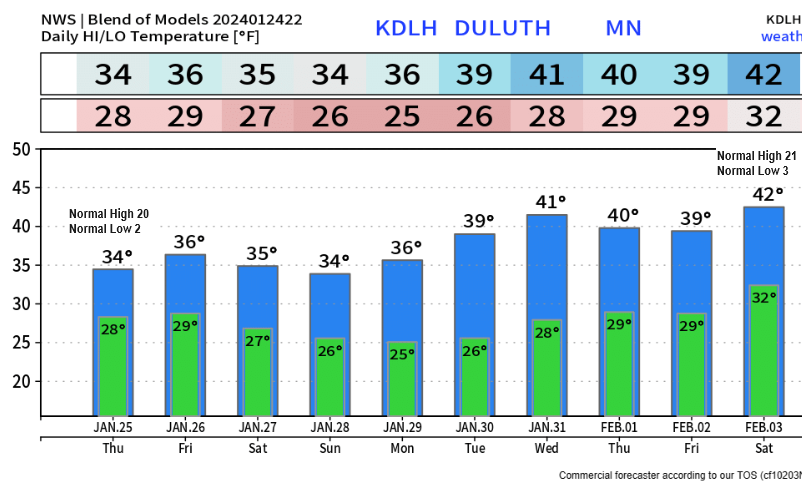
Mild temperatures persist the rest of this week and through next week with highs in the 30s with some 40s likely on a few days next week. Low temperatures will also be very mild for this time of the year and will mainly be in the 20s and 30s through next week.
Note: Record highs and record warm lows are possible on a few days in the Northland through next week.
Today’s highs and departure from normal for January 24.
Ashland: 36 (+14 degrees above normal)
Brainerd: 34 (+13 degrees above normal)
Duluth: 32 (+12 degrees above normal)
Hibbing: 32 (+15 degrees above normal)
International Falls: 31 (+15 degrees above normal)
Also of note were the lows this morning which were running some +25 to as much as +35 degrees above normal in the Northland for January 24th.
HRRR model visibility forecast through 6 PM Thursday.
Darker colored areas represent visibility of <1 mile.

Active weather continues across the western U.S., and also across the southern and eastern U.S., including parts of the Midwest and eastern Great Lakes.
Note: The pattern may turn a little more active in the Northland sometime in the February 4th-8th time frame but not a lot going on before then.
Total precipitation forecast through February 3rd.

A strong upper-level trough located west of Seattle and a strong upper-level ridge east of Miami is leading to a southwest flow aloft across the central/eastern U.S. today with plenty of moisture streaming north-northeast out of the Gulf of Mexico today.

Water vapor loop from today ending 4:45 PM CT.

Widespread rain (green) and fog (gray) across the southern, central and eastern U.S. today and also over parts of the western U.S.
Note the lack of snow reports (blue) considering that it’s late January.

Radar from late this afternoon
Note: Flash Flood Warnings (green outlined areas) in parts of Louisiana and Mississippi today.

Still seeing a lot of arctic air well to our north today with temperatures only in the teens, 20s and 30s below zero today, but winds aloft won’t be in a favorable direction to send this arctic air south into the Northland at least through early February.

For now, it’s all about milder Pacific air with even some early summer warmth across the southeast U.S. with temperatures in the mid 70s to low 80s today in Florida.

Thanks for reading!
Tim
Leave a Reply