6:15 PM Monday, January 29, 2024
-A few light snow or rain showers are possible in parts of the Northland tonight otherwise the rest of this week looks dry, and this dry pattern should continue into at least early next week.
-Seasonal snowfall total for Duluth is at 17.1 inches. Normal snowfall to date is 51.4 inches. Snowfall deficit of -34.3 inches below normal. 80.1 inches of snow had fallen in Duluth by this time last winter.
-Winds will increase out of the northwest tonight with wind gusts of 15 to 30 mph, and these gusty winds will linger into Tuesday morning before diminishing Tuesday afternoon.
-Wednesday looks like the warmest day of the week with widespread 40s expected in the Northland with a slight chance for an isolated 50 degree temperature.
-No arctic air/subzero temperatures expected at least through early February, and perhaps right through mid-February.
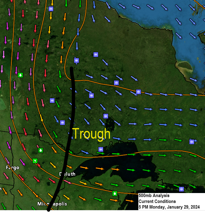
A fairly strong mid and upper-level system is digging south/east out of Ontario today, but this system hasn’t been producing a whole lot of precipitation in the Northland today.
Goes-16 water vapor loop from late Monday afternoon.

A few light snow or rain showers in parts of the Northland tonight into early Tuesday morning. Any snow that falls shouldn’t amount to much with less than an inch of accumulation.
HRRR model simulated radar forecast through 6 AM Tuesday.

We saw quite a bit of variability in sky conditions across the area this afternoon.

Temperatures in Duluth over the next 10 days will continue to be well above normal for this time of the year with temperatures nowhere close to the normal highs or lows through February 8th.

A quiet weather pattern will continue in the Northland this week with a strong upper-level ridge centered over central Canada which will keep our area mostly dry, while an active pattern continues in the western U.S. and later this week in parts of the central Plains and southern U.S.
EPS model 500mb forecast valid through February 3, 2024.

Next week sees a bit of a pattern change as we may get into a southwest flow aloft in the upper Midwest while a deep trough covers the western U.S. and also over the Atlantic Ocean while a strong ridge shifts slightly farther east into eastern Canada.
Note: There is a chance that we may see the pattern turn slightly more active in the Northland sometime mid to late next week.
EPS model 500mb forecast valid February 4-9, 2024.

Above normal temperatures continue in the Northland possibly all the way through mid-February.
EPS model temperature anomaly forecast valid through February 3, 2024.

EPS model temperature anomaly forecast valid February 4-9, 2024.

High temperature reports from Sunday, January 28, 2024
Source: National Weather Service Duluth, Minnesota
Cass Lake, MN: 50
Walker, MN: 45
International Falls, MN: 43
Orr, MN: 43
Cook, MN: 43
Longville, MN: 43
Pine River, MN: 43
Hibbing, MN: 41
Bigfork, MN: 41
Ashland, WI: 40
Duluth Airport: 39
Crane Lake, MN: 39
Eveleth, MN: 39
Two Harbors, MN: 39
Grand Marais Airport: 39
Superior Airport: 38
Grand Rapids, MN: 38
Brainerd, MN: 37
Duluth Sky Harbor Airport: 37
Ely, MN: 36
New daily record high temperatures set Sunday.
International Falls, Minnesota
New record high for 1/28: 43
Old record high for 1/28: 38 set in 1922
Hibbing, Minnesota
New record high for 1/28: 41
Old record high for 1/28: 40 set in 1989
Note: Hibbing also set a new daily record high temperature today with a high of 38 degrees. The old record high for January 29th was 37 set in 1992.
Record warm low temperatures broken or tied over the weekend.
Hibbing, Minnesota
New record warm low for 1/28: 25
Old record warm low for 1/28: 24 set in 2015, 2013, and 1995
Hibbing, Minnesota
New record warm low for 1/27: 28
Old record warm low for 1/27: 25 set in 2015 and 2006
Ashland, Wisconsin
Low of 33 on Saturday which ties the record warm low temperature of 33 which was set on January 27, 2006.
Thanks for reading!
Tim
Leave a Reply