6:07 PM Tuesday, February 6, 2024
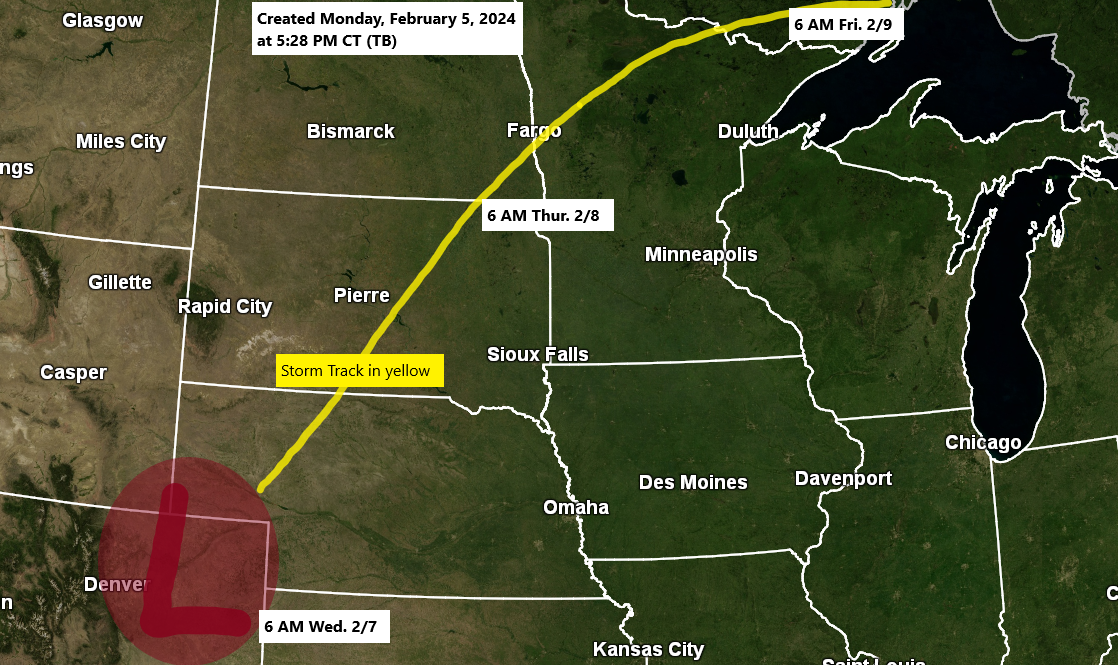
An area of low pressure will track from northeast Colorado to near/west of International Falls between Wednesday morning and Thursday evening, and then will see this low pass north of Lake Superior by around daybreak on Friday.
With the low passing west of the Northland this will keep our area in the milder air ahead of this system with waves of light to moderate rain likely as those waves of rain lift north/northeast across the Northland beginning Wednesday afternoon but more likely Wednesday night and continuing during the day Thursday.
Some more precipitation is likely Thursday night into Friday and will also mix in some cooler air as the low departs so will likely see the rain change over to snow showers and flurries in much of the Northland either late Thursday night or on Friday with an inch or less of snow accumulation possible in parts of the Northland by Friday evening.
HRRR model simulated radar forecast valid 12 PM Wednesday to 12 PM Thursday.

Rainfall totals have decreased a bit with this next system with rain totals now looking to be mostly around a quarter inch in northwest Wisconsin while a quarter to half inch of rain is possible in northeast Minnesota.

That is one large system across the western U.S. today as seen on water vapor imagery. This is the system that will be affecting the Northland the next few days but one would think this would be quite a storm by how it looks on vapor imagery today, but it really won’t be in terms of how much precipitation and wind we see out of it.

Note the purple colors east of Florida on the map below, those represent surface pressure anomalies of around -6 sigma this morning, or in other words a pretty strong system for this time of the year.
The system which will affect the northern Plains and upper Midwest are forecast to have surface pressure anomalies of around -3 sigma.
EPS model surface anomaly forecast through 6 AM Friday.

Today’s highs and departures from normal for February 6th
Ashland: 50 (+26 degrees above normal)
Duluth: 44 (+22 degrees above normal)
Brainerd: 43 (+19 degrees above normal)
Hibbing: 41 (+22 degrees above normal)
International Falls: 36 (+18 degrees above normal)
Note: Today, February 6th marked the 17th day in a row with an above average temperature in Duluth.
83% of days this winter have been warmer than average in Duluth compared to just 15% of days which have been colder than average.

Average temperatures and departures from normal in the Northland for February 2024 (thru the 5th)
Duluth, MN: 31.3 degrees (+19.3 degrees above normal)
Ashland, WI: 31.2 degrees (+17.2 degrees above normal)
Brainerd, MN: 30.2 degrees (+18.6 degrees above normal)
Hibbing, MN: 28.3 degrees (+21.5 degrees above normal)
International Falls, MN: 28.2 degrees (+22.4 degrees above normal)
Warmest February on record
- Duluth: 31.3 degrees set in 1877
- Ashland: 26.9 degrees set in 1987
- Brainerd: 29.4 degrees set in 1998
- Hibbing: 28.3 degrees set in 1998
- International Falls: 27.1 degrees set in 1998
February is off to an incredibly warm start across the upper Midwest, and Plains where average monthly temperatures are running some +15 to +25 degrees above normal.

Thanks for reading!
Tim
Leave a Reply