6:11 PM Wednesday, February 7, 2024
A wet system will cross the Northland tonight into Thursday as an area of low-pressure tracks from northeast Colorado to far northwest Minnesota by Thursday evening. This low will then track to the north of Lake Superior on Friday.
A mild southerly flow ahead of this system means that will see rain in the Northland tonight and Thursday, but as cooler air moves into the area behind the low Thursday night into Friday will see the rain showers mix with and change to snow showers and flurries with snowfall accumulations of a trace to an inch in parts of the area.
Breezy east to southeast winds will occur tonight and Thursday with wind gusts up to 30 mph. Winds will then shift to the southwest Thursday night and to the northwest on Friday with wind gusts of 15 to 30 mph.
Mild temperatures will continue on Thursday with highs in the 40s in the Northland with some 50s in northwest Wisconsin. Cooler temperatures finally return on Friday and through this weekend with highs in the 20s to lower 30s with lows in the teens and 20s Friday night and Saturday night. Note: Although temperatures will be turning cooler Friday into this weekend, they will still be running above normal for this time of the year.
- The record high temperature of 48 degrees for February 7th was tied today at Brainerd, Minnesota today with a high of 48 degrees. This record was first set in 1987.
Surface map from late Wednesday afternoon and the storm track forecast through Friday morning.

-The bulk of the rain tonight should remain over central and northern Minnesota with a lesser chance of rain in northwest Wisconsin.
-Rain chances increase during the day Thursday in northwest Wisconsin while rain continues at times in northeast Minnesota.
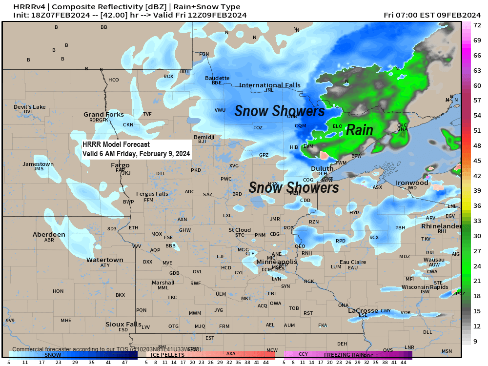
-Rain changes to snow showers and flurries Thursday night or Friday.
Duluth area: Most of tonight should be dry. Rain chances increase Thursday morning with some rain likely Thursday afternoon into Thursday evening. Rain switches over to some snow showers and flurries either late Thursday night or Friday.
HRRR model simulated radar forecast through 1 PM Friday.
Rain (green)
Snow (blue)

There’s no shortage of moisture moving into the Northland with this system with precipitable water averaging around 0.75″ through Thursday which is quite high in our area for this time of the year. Note: With the higher amounts of moisture in the air this could lead to some heavier downpours on Thursday.

Rainfall totals ranging from around 0.25″ to 0.50″ are likely in much of northeast Minnesota through Thursday evening with 0.10″ to 0.25″ of rain likely in much of northwest Wisconsin.

Snowfall totals of a trace to 1 inch are possible in parts of the Northland on Friday.

Quite a large system lifting northeast out of the Rockies and Plains tonight.
Goes-16 water vapor loop from Wednesday ending 5:45 PM CT.

A broad upper-level trough over the western U.S. will move north/east across the upper Midwest on Thursday before this trough pulls off to the east on Friday.

A classic storm signature in place today with mild temps ahead of an area of low pressure and colder air behind the low, and that low was centered northeast of Denver late today.

Thanks for reading!
Tim
Leave a Reply