6:06 PM Friday, February 9, 2024
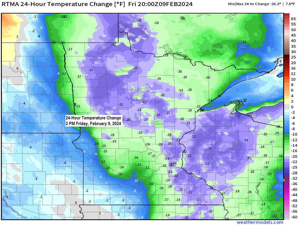
Cooler temperatures returned to the Northland today with temperatures running a good -15 to around -25 degrees colder this afternoon compared to Thursday afternoon’s temperatures.
There’s also been a little snow at times across the Northland today with snowfall amounts mostly under an inch including 0.3 inches at International Falls, and 0.1 inches at Duluth.
No major systems will be impacting the Northland at least through the middle of next week as we see a northwest flow aloft develop with our only chances for getting a little snow coming from mostly weak clipper systems moving southeast out of Canada.
Above normal temperatures continue in Duluth through midweek but certainly not as warm as it has been lately. There is a chance we could see a brief shot of much colder temperatures next Friday-Saturday, but that’s about the only chance we have for some arctic air and subzero temperatures looking out the next 10 days.

Mild temperatures covered much of the southern U.S. today with cooler temperatures farther north, while arctic air remains bottled up across northern Canada today.
Temperatures and 500mb analysis from late Friday afternoon.

Our very mild winter continues.
Average temperature ranks by state for winter 2023-2024 (thru Feb.9)
Minnesota: Warmest on record.
Wisconsin: Warmest on record.
Michigan: Warmest on record.
Iowa: 4th warmest on record.
North Dakota: 5th warmest on record.

Temperature streaks we’ve seen this winter in Duluth.
By far the above average temperature streaks have been the norm. this winter.
- 11 days in a row with an above average temperature (Dec. 1-11)
- 16 days in a row with an above average temperature (Dec. 19-Jan. 3)
- 9 days in a row with a below average temperature (Jan. 12-20)
- 20 days in a row and counting with an above average temperature (Jan. 21-Feb. 9)
Here’s a look at the daily average temperature departure this winter in Duluth.
Red: Warmer than average
Blue: Colder than average

Record warm low temperatures were set or tied in the Northland on Thursday.
Ashland, WI: New record 40 degrees. Old record 35 degrees set on February 8, 1991.
Duluth, MN: Tied the record warm low for November 8th of 36 degrees. This record was set on February 8, 1886.
International Falls, MN: New record 36 degrees. Old record 28 degrees set February 8, 1999.
Hibbing, MN: New record 35 degrees. Old record 32 degrees set on February 8, 1999.
Long Range Snowfall Trends
No major snow events showing up in the computer models at least through the middle of next week, but there is some noise at least in the GEFS model when it comes to the possibility for something a little more significant in terms of snowfall potential, but that’s more toward the end of next week and beyond, so way out in the extended forecast which means the chances for that to actually happen are still pretty low.
But for what it’s worth, there’s currently 9/20 or 45% of GEFS model members showing 6″ or more of snow (outlined in black on the image below) in Duluth by February 25th.

11/50 or 22% of EPS members are showing 6 inches or more of snow in Duluth through February 23rd, so again fairly low odds for getting a lot of snow in Duluth over roughly the next 2 weeks.

First February tornado on record in Wisconsin on Thursday.
Time: 5:37 PM CT.
Location: 2 miles north-northwest of Albany, WI (Green County)
In addition to the severe weather in southern Wisconsin Thursday, there was also severe weather in central and northern Illinois with 2 preliminary tornado reports.

Thanks for reading!
Tim
Leave a Reply