5:56 PM Friday, February 16, 2024
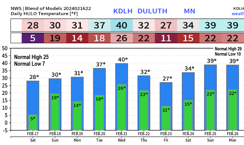
We have a few chances for temperatures of around 40 degrees in Duluth in the next 10 days including for the middle of next week, and again next weekend, but we also have a few brief shots of cold air, and one of those continues tonight into Saturday morning, and we may see another cold shot sometime late next week.
Note: If the temperature doesn’t drop below zero in Duluth tonight (pretty good chance it won’t) then we may go the entire month of February without a subzero temperature, and having no subzero temperatures in Duluth during the month of February is rare as it’s only happened 4 other times in station history dating back to 1875. Those years where we had no subzero low temps in Duluth in February include 1998, 1882, 1878, and 1877.
Snow drought continues in Duluth this winter with just 0.6 inches of snow so far this month, and just 17.7 inches of snow since October 1st which is -42.8 inches below normal to date.
Our streak of above average days in Duluth ends at 26 days in a row as today’s average temperature was -7 degrees below normal making it the first below average day in Duluth since January 20th.

Looks like we could see a few snow showers late tonight through Saturday morning in parts of northeast Minnesota, but accumulations should stay under an inch.
NAM 3km model simulated radar forecast valid 6 AM to 12 PM Saturday.

No major storm systems will be affecting the Northland through next week, but we will likely see a couple cold fronts move through our area along with an occasional clipper type system coming out Canada which will lead to a chance for a few light snow showers at times tomorrow morning and again late next week but again no major snow events hitting our area the way it looks now.
One thing to keep an eye on for late next week is on the possibility of that upper low/trough centered near James Bay Canada digging farther south and possibly southwest for a brief time if we see the upper-level pattern amplify enough, and computer models have been trending toward a more amplify weather pattern late next week which could cause another brief shot of cold air to affect the Northland sometime in the February 22-24 timeframe.
EPS model 500mb forecast.

EPS model temperature anomaly forecast.

Thanks for reading!
Tim
Leave a Reply