6:25 PM Wednesday, February 21, 2024
Another mild day ahead on Thursday with highs mostly in the 40s in the Northland but a few locations in northwest Wisconsin could get up to around 50 degrees.
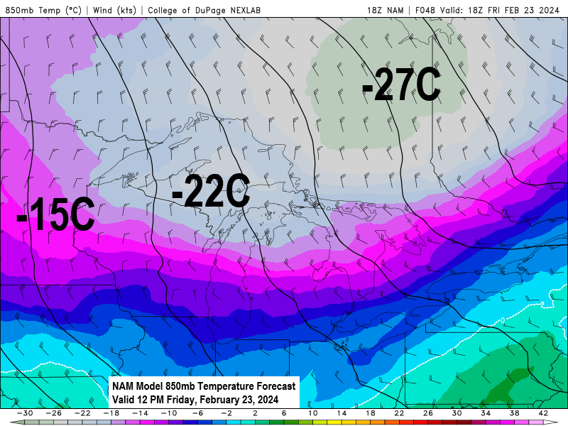
A shot of much colder temperatures arrives Thursday night and sticks around through Friday night with lows both nights ranging from around 5 below to 15 above zero, with highs Friday ranging from the middle teens to middle 20s (coldest temps in northern Minnesota). Gusty north winds are also likely Thursday night into Friday with wind gusts of 20 to 30 mph.
Note: Still haven’t seen a subzero temperature this month in Duluth and it looks like temperatures will stay above 0 during this brief late week cold snap in Duluth. The only years where we didn’t have any subzero temperatures in February in Duluth are 1998, 1882, 1878, and 1877. Computer models are showing the potential for another brief cold snap around February 28th-29th, and that would be our last final shot at getting a subzero temperature this month in Duluth.
A more active weather pattern is still possible for next week as will see a trough over the western U.S. move east and northeast into the Plains. The timing of this trough, and whether or not will see an area of low pressure develop, and if one develops how strong will it be, and the track of any such system is still very uncertain today. But there is at least some potential for a system to impact parts of the upper Midwest including for us in the Northland around February 27th-29th with a chance for some rain or snow. Stay tuned.

Note: Only 0.6 inches of snow so far this month in Duluth. The least snowy February on record is 2.1 inches set in 1896.
Here’s the NWS Blend of Models total snowfall forecast through next Thursday.

NWS Blend of Models total precipitation forecast through next Thursday.

A mild late February day in the Northland with temperatures ranging from the upper 30s to upper 40s with a few locations in the lower 50s this afternoon.
Brainerd, Minnesota set a new record high temperature today with a high of 53 degrees. The old record high for February 21st was 52 degrees set in 1931, 1981, and 2017.
Today’s highs and departures from normal for February 21st
*=Daily record high temperature set
Brainerd: *53 (+24 degrees above normal)
Ashland: 47 (+18 degrees above normal)
Duluth: 46 (+19 degrees above normal)
International Falls: 41 (+17 degrees above normal)
Hibbing: 39 (+14 degrees above normal)

We have some early summer like temperatures in the 70s and 80s in the southern Plains today with at least one location in Texas in the 90s (Fort Stockton with a temperature of 91 at 4 PM today).

Temperatures were running some +20 to +30 degrees above normal in the northern Plains and upper Midwest this afternoon and look at just how much of the lower 48 was covered by above normal temperatures today (red and white colors on the map below.

Meanwhile farther to the north there’s still a rather large area of arctic air over northern Canada around the Hudson Bay area with temperatures in the -20s and -30s today along with wind chills as cold as the-40s, -50s and -60s.

Two large low-pressure systems, one over the Pacific, the other over the Atlantic today.
Water vapor loop from today (ending 4:50 PM CT)

Thanks for reading!
Tim
Leave a Reply