5:23 PM Tuesday, April 2, 2024
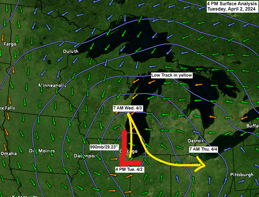
A powerful spring storm will impact much of Wisconsin and upper Michigan tonight and Wednesday as a strong area of low-pressure lifts slowly north out of the Chicago area tonight, and then will see this low shift back toward the south-southeast on Wednesday with this low moving over northern Ohio by early Thursday morning.
This storm will bring widespread snow and strong north winds to much of Wisconsin and upper Michigan tonight and Wednesday with blizzard conditions expected in parts of upper Michigan around the Marquette area.
The Northland will remain on the northwest edge of this storm with accumulating snow likely in parts of northwest Wisconsin through Wednesday night with some light snow tonight with little accumulation for northeast Minnesota including the Twin Ports area.
HRRR model simulated radar forecast through 7 AM Thursday.

Winter Weather Alerts as of late Tuesday afternoon.

Zoomed in view of the blizzard warning in upper Michigan.

Widespread snowfall totals of 6 or more inches are likely through Wednesday stretching from south central to eastern to northeast Wisconsin into much of upper Michigan with a snowfall maximum of 24 inches or more near and to the west/south of Marquette.
Locally for the Northland
Snowfall totals of 6 to 10 inches are possible through Wednesday evening in parts of northwest Wisconsin south and east of Ashland with amounts ranging from 1 to 6 inches for most of the rest of northwest Wisconsin.
Less than an inch of snow tonight in far eastern Minnesota, Twin Ports, North Shore, and Arrowhead.

A powerful mid-latitude cyclone on full display this afternoon with snow (blue colors) in the colder air with rain and thunderstorms (green/yellow colors) in the warmer air.
Red outlined areas: Tornado Warnings as of 4:48 PM.
Yellow outlined area: Severe Thunderstorm Warning as of 4:48 PM.
Green outlined area: Flash Flood Warning.

This strong spring storm will produce widespread high winds through Wednesday night.
850mb wind speeds will increase to between 50 to around 70 knots (red and purple colors on the loop below) across parts of the upper Midwest and western Great Lakes tonight into Wednesday.
NAM model 850mb wind forecast through 7 AM Thursday.

- Wind gusts of 30 to 45 mph are possible in northwest Wisconsin through Wednesday evening.
- Wind gusts of 20 to 35 mph are possible in northeast Minnesota through Wednesday evening.
HRRR model wind gust forecast through 7 PM Wednesday.

Storm Warning (purple area on map) is in effect from 10 PM this evening to 7 AM Thursday for central and southern portions of Lake Superior with north winds to 50 knots and waves of 14 to 19 feet expected.

Two mid-level lows and a broad trough covering the upper Midwest this afternoon.
Will see the two mid-level lows phase into one main low on Wednesday as it tracks toward the Ohio Valley.

Here’s a look at this major spring storm on Goes-16 satellite imagery Tuesday afternoon.
Goes-16 infrared satellite loop ending 4:51 PM Tuesday.

Goes-16 water vapor loop ending 4:56 PM Tuesday.

This storm also has a severe side with several tornado watches in effect through this evening.

Thanks for reading!
Tim
Leave a Reply