4:54 PM Thursday, April 4, 2024
- Quiet weather conditions the next few days
- A weakening system could bring a little rain or a rain/snow mix to parts of the Northland early next week
- Stronger lake wind develops this weekend keeping temperatures in the 30s close to Lake Superior (40s and 50s farther inland)
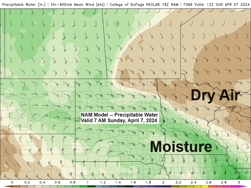
A lot of dry air will be in place across the Northland this weekend with precipitable water of around a quarter inch or less while deeper moisture will be found farther to the south. Eventually some of that deeper moisture will lift north but how far north and just how much moisture lifts north into our area is uncertain right now.
Currently it looks like the greatest amounts of precipitation with this weekend’s system will fall south of the Northland Sunday-Monday with mostly light precipitation farther north including for the Twin Ports and northwest Wisconsin. The Arrowhead and far northern Minnesota could miss out on getting any precipitation early next week the way it looks now.
Temperatures should be warm enough where we see mostly rain in our area early next week, but there is a chance for a little wintry mix in some parts of the Northland if enough cold air is available which looks like a low chance right now.

Gusty northeast winds are expected near Lake Superior this weekend due to a tight pressure gradient between low pressure over the western High Plains and high pressure over Ontario. Wind gusts of 20 to around 35 mph are expected near Lake Superior Saturday afternoon through Monday.
European model wind gust forecast valid 1 PM Saturday to 7 PM Monday.

An amplified early spring weather pattern has setup across the U.S. today with two strong upper-level troughs along with a strong upper-level ridge. The Northland is currently in the ridge portion of this pattern, and this will remain the case at least through Saturday.

Notice how well the temperature pattern resembles the 500mb pattern today.
Cooler air where the troughs are, while warmer air is found near the ridge today, including temperatures in the 70s in eastern Montana!

Still dealing with the effects of a large storm system over the eastern U.S. today with more clouds in eastern portions of northwest Wisconsin which is helping to keep temperatures in the 30s this afternoon, while sunshine is more abundant farther to the west with temperatures in the middle 40s to lower 50s this afternoon.
Normal highs on April 4th
Brainerd: 49
Ashland: 45
International Falls: 45
Duluth: 44
Hibbing: 44

Thanks for reading!
Tim
Leave a Reply