5:31 PM Friday, April 5, 2024
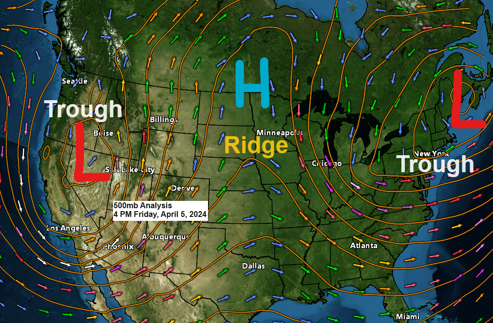
An amplified weather pattern continues today with two strong upper-level troughs and one large upper-level ridge. The Northland is still in the ridge portion of this pattern today, but eventually this ridge gets pushed off to the east by a trough which approaches from the western U.S. this weekend, and that trough will then linger over the upper Midwest into early next week.
At the surface, will see a strong area of low pressure initially over the Rockies move out onto the western High Plains on Saturday, and that low will then track generally to the northeast as it moves from central Nebraska toward northeast Iowa, southeast Minnesota, or southwest Wisconsin between Sunday morning and Monday morning.
This low will be at its strongest on Sunday with a central pressure of around 990mb or less, but as this low moves farther to the northeast and into the upper Midwest it will weaken quite a bit as the central pressure rises to >1000mb by Monday morning.
This system will likely bring some precipitation to much of the Northland Sunday afternoon through Monday night and this precipitation will spread slowly north Sunday afternoon/evening, reaching the Duluth area later Sunday afternoon (~3 PM to 5 PM) the way it looks now but this could be delayed a bit depending on how long it takes for the atmosphere to saturate.
Precipitation type with this system looks to mostly be rain in the Northland but there is a chance for some wet snow or a rain/snow mix Sunday night-Monday morning mainly along the North Shore of Lake Superior in the higher terrain areas inland from Lake Superior.
At the moment it doesn’t look like will see any snow in Duluth from this system with mostly rain expected.

European model simulated radar forecast valid 7 AM Sunday to 1 AM Tuesday.
Rain (green)
Snow (blue)
Wintry Mix (pink)

Much of central, eastern and southern Minnesota into west central Wisconsin could get a half inch or more of precipitation out of this system this weekend into early next week with lesser amounts of precipitation expected the farther north you go including for the Twin Ports, North Shore, and Arrowhead with around 0.10 to 0.40 inches of precipitation possible.

There is also a chance that we could see some wet snow or a rain/snow mix in parts of central Minnesota on Sunday, and along the North Shore of Lake Superior Sunday night into Monday morning. Slushy snowfall accumulations of a trace to an inch are possible in the aforementioned areas.

Northeast wind will be increasing near Lake Superior this weekend with wind gusts of 20 to 35 mph with the strongest winds expected on Sunday when we could see wind gusts to around 40 mph.
European model wind gust forecast valid 1 PM Saturday to 7 PM Monday.

A very amplified pattern today.
Goes-16 water vapor loop ending 3:50 PM CT Friday, April 5, 2024.

Today’s highs and departure from normal for April 5th
Brainerd: 56 (+7 degrees above normal)
Hibbing: 53 (+9 degrees above normal)
International Falls: 50 (+5 degrees above normal)
Ashland: 44 (-2 degrees below normal)
Duluth: 43 (-1 degree below normal)
A nice early spring day across the area with widespread 50s with even a few 60s in the Dakotas this afternoon.
An east wind kept temperatures cooler and in the upper 30s and 40s near Lake Superior today and get use to those east winds because they will stick around at least through Monday.

Thanks for reading!
Tim
Leave a Reply