5:49 PM Saturday, April 6, 2024
- Strong northeast wind continues near Lake Superior including in the Duluth area through Monday.
- Rain spreads slowly north out of southern and central Minnesota Sunday.
- Rain continues Sunday night through Monday night.
- A few showers possible midweek.
- Temperatures could be up around 60 in Duluth Wednesday afternoon.
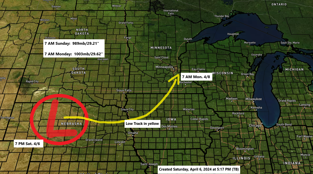
A strong area of low pressure was over western Nebraska this afternoon and this low will deepen a little more through Sunday morning before it begins to weaken as it lifts northeast into southern Minnesota around daybreak on Monday.
This storm will bring rain to much of the Northland beginning Sunday afternoon with some rain continuing through Monday night with the greatest rainfall totals expected in east central Minnesota and northwest Wisconsin including the Twin Ports and parts of the North Shore of Lake Superior with much lower rainfall amounts expected in far northern Minnesota including for the International Falls area.
Temperatures will be milder with this system compared to the last system which brought heavy snow to the Northland, but there is still a chance that we could see a little wet snow or a rain/snow mix at times Sunday night into Monday morning especially along the North Shore of Lake Superior in the higher terrain inland from Lake Superior. Note: No snow is expected with this system in Duluth.
Very strong winds have been occurring over parts of Wyoming, Colorado, Nebraska, and Kansas with today’s storm with winds outside of thunderstorms gusting as high as 65 mph. There’s also been reports of dust storms in northwest Kansas today due to these very strong winds.

Nice looking system spinning over the central Plains today.
Goes-16 visible satellite loop ending 5:11 PM CT Saturday, April 6, 2024.

For Duluth: Rain begins Sunday afternoon around 3 PM to 5 PM but it should be dry before then.
HRRR model simulated radar forecast valid 7 AM Sunday to 1 PM Monday.

It will take time for the rain to spread north into our area on Sunday with a lot of dry air in place Sunday morning with precipitable water of less than a quarter inch. But eventually the deeper moisture will push farther north out of southern Minnesota, but it may take until Sunday night for this to occur especially across northern Minnesota.

Rainfall amounts have increased a bit with this system with totals now looking to be in the 0.50″ to 0.80″ range in east central Minnesota and northwest Wisconsin and from Duluth and along parts of the North Shore of Lake Superior.
Much lower rainfall amounts are still expected in far northern Minnesota.

Still could see a little wet snow Sunday night into Monday morning along the North Shore of Lake Superior in the higher terrain with slushy accumulations of a trace to 1″ possible.

Windy conditions will continue across the Northland through Sunday night with east to southeast winds gusting 20 to around 40 mph, with even stronger winds likely near Lake Superior where east to northeast winds could gust to 45 mph at times through Monday morning.
HRRR model wind gust forecast through 7 AM Monday.

There is a threat of severe thunderstorms this evening in parts of the central Plains with damaging wind gusts to 75 mph being the primary hazard, but isolated large hail and a tornado is also possible.

A more active pattern has arrived.
Looking at 3 systems over the next week or so.
System 1 impacts the Northland the next few days.

System 2 takes a more southerly track and should miss the Northland mid to late next week.

System 3 could develop next weekend, and this one could take a more northerly track while impacting the Northland sometime in the April 13-16 timeframe.

Thanks for reading!
Tim
Leave a Reply