5:05 PM Sunday, April 7, 2024
An initial wave of rain will continue to lift north out of east central Minnesota and northwest Wisconsin this evening but as this rain lifts farther north it will likely diminish quite a bit due to the amount of dry air in place in northern Minnesota and Arrowhead.
More rain is then expected to develop later tonight/early Monday morning, and this next round of rain should have a better chance at reaching far northern Minnesota as the dry air begins to move away on Monday.
Duluth area: Expect a rainy 24 hours or so with light to moderate rain along with some drizzle. Patchy fog is also possible Monday. Gusty northeast wind to 40 mph tonight (strongest this evening). More breezy conditions Monday with a northeast wind gusting 15 to 30 mph. Highs Monday ranging from 37 to 40 degrees. Midweek looks better with highs near 50 Tuesday, and near 60 Wednesday.
NAM 3km model simulated radar forecast through Midnight Tuesday.

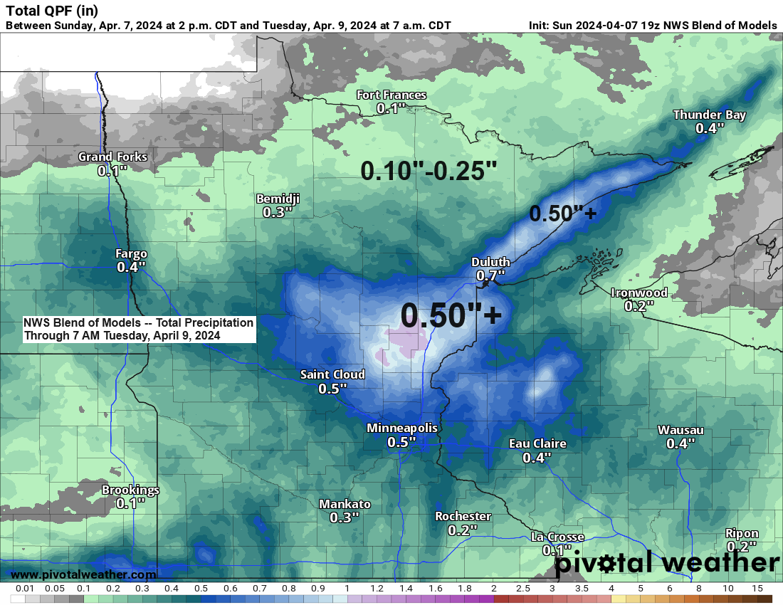
A strong area of low pressure over far northeast Nebraska this afternoon will continue to lift slowly northeast into southern-eastern Minnesota on Monday with the center of the low passing near/west of the Twin Cities around daybreak on Monday. As this low tracks’ northeast, it will continue to weaken as seen in the central pressure of the low which rises from 997mb at 3 PM today to around 1003mb around 7 AM Monday.
This system although weakening will still produce a widespread light to moderate rain event in much of northeast Minnesota and northwest Wisconsin tonight through Monday night.

This system is vertically stacked meaning the surface and mid/upper-level lows are pretty much right over each other, and this results in a slow moving but also a weakening system as it continues to lift northeast into the upper Midwest through Monday.

Goes-16 visible satellite loop ending 3:11 PM CT Sunday, April 7, 2024.

Precipitation so far this spring is running pretty close to normal in Duluth and in much of northeast Minnesota, while this spring has been pretty wet so far in northwest Wisconsin.
Precipitation stats for Duluth since March 1st
Total: 1.96″
Normal: 1.88″
Departure: +0.08″ above normal
Percent of normal precipitation: 104% of normal
Precipitation stats for International Falls since March 1st
Total: 1.16″
Normal: 1.31″
Departure: -0.15″ below normal
Percent of normal precipitation: 88% of normal


Looks like will finally get our 1st 50 and possibly the 1st 60 of the month this week in Duluth.
- Average number of days in April with a high of at least 50 in Duluth is 11 days.
- Average number of days in April with a high of at least 60 in Duluth is 5 days.
And to those wondering, the average date of the 1st 70 degree temperature in Duluth is April 28th. Earliest was on March 7th (2000), and the latest was on June 14th (1907)
Note: Last year’s 1st 70 in Duluth was on May 10th.
Will have a shot at hitting 50 degrees in Duluth Tuesday, and then on Wednesday if things setup right we could be looking at temperatures near 60 degrees during the afternoon.

Thanks for reading!
Tim
Leave a Reply