6:41 PM Thursday, April 11, 2024
Summer-like warmth is expected in parts of Minnesota, particularly the west central and southern regions, this weekend and into early next week. Temperatures are forecasted to reach the 70s and 80s, with Saturday and the following Monday anticipated to be the warmest days.
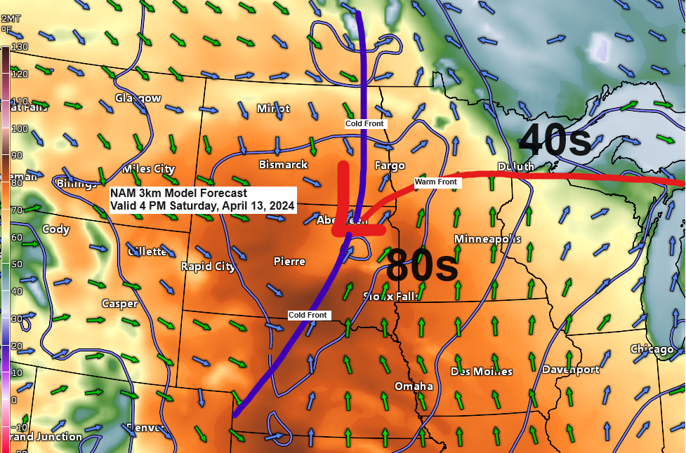
The Northland won’t experience any temperatures in the 80s this weekend or early next week. However, we can still expect mild weather with highs in the 60s to around 70 degrees. Near Lake Superior, it will be significantly cooler on Saturday and again early next week, with easterly winds keeping temperatures in the 40s.
Duluth marked its second day of the month with a temperature reaching 60 degrees today. Typically, the average number of days in April with temperatures of 60 degrees is five.
A low-pressure system, accompanied by its associated warm and cold fronts, is anticipated to move across the Northland from Saturday into early Sunday. This weather system could result in scattered showers or isolated thunderstorms in some areas on Saturday.
A significantly larger and more intense low-pressure system is expected to affect the Northland area early next week, bringing widespread rain and likely gusty winds. While a few thunderstorms may occur next Monday and Tuesday, severe thunderstorms are not anticipated in the far north at this time.

Early next week, much of northeast Minnesota and northwest Wisconsin could receive widespread rainfall, with totals reaching an inch or more.

The Northland experienced another day of scattered showers, with some leading to brief heavy downpours, small hail in certain areas, and the occasional lightning strike. These showers are expected to taper off later in the evening as daytime heating subsides.

Today’s showers resulted from an upper-level trough over the upper Midwest and western Great Lakes. This trough, along with colder air aloft and daytime heating, produced some atmospheric instability, leading to the formation of showers.

Currently, a robust area of low pressure is centered over southwest Ohio. This system is expected to move northeastward, reaching Lake Huron by early Friday morning. As it progresses, the low is forecast to intensify, with central pressure decreasing to approximately 980 millibars by Friday morning.

Goes-16 visible satellite loop ending 4:41 PM CT, Thursday, April 11, 2024.

Here’s a look at today’s system impacting the Ohio Valley and Great Lakes.
Goes-16 enhanced water vapor loop ending 4:46 PM CT, Thursday, April 11, 2024.

Thanks for reading!
Tim
Leave a Reply