4:56 PM Sunday, April 28, 2024
Another low-pressure system is set to impact the Northland area tonight and into Monday. This system is expected to bring widespread precipitation across the Northland, accompanied by strong northeasterly winds, especially near Lake Superior.
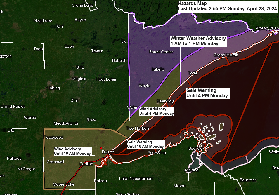
In northern Minnesota, near the Ontario border, areas such as International Falls and eastward into the Arrowhead region may experience a transition from rain to snow on Monday morning. Additionally, there is a possibility of patchy freezing rain early Monday morning across the elevated areas of the North Shore of Lake Superior.
Duluth area: Tonight’s steady, wind-driven rain will taper off to intermittent showers and drizzle from early Monday morning through Monday evening. Expect areas of fog both tonight and Monday. Northeast winds will gust up to 50 mph tonight into Monday morning, then decrease by Monday afternoon with gusts reaching up to 35 mph. Note: Duluth is not forecasted to receive ice or snow tonight or Monday, but conditions could be borderline, particularly in elevated areas this evening.
Precipitation is expected to progress slowly northward this evening, reaching the far northern regions of Minnesota and the Arrowhead area after midnight tonight.
The primary band of precipitation linked to this system is expected to happen tonight into early Monday morning. However, some precipitation is likely to continue throughout Monday before the system moves northeastward and exits Monday night.
NAM 3km model simulated radar forecast through 7 PM Monday.

The Northland is expected to receive an additional half inch of precipitation by Monday evening, with certain regions potentially seeing amounts nearing an inch or more. This is particularly likely in east central Minnesota, especially around the Brainerd, Aitkin, and Hinckley areas.

Ice accumulations up to a tenth of an inch may occur Monday morning along the North Shore of Lake Superior and into the Arrowhead, particularly on the elevated terrain inland from the lake.

Accumulations of snow ranging from a trace to 2 inches may occur on Monday morning in the far northern regions of Minnesota.

Strong northeast winds are expected to persist in the Lake Superior and Duluth area tonight and into Monday, driven by a tight pressure gradient between a robust high near James Bay, Canada, and a low-pressure system ascending northeast from eastern Nebraska.
Northeast winds ranging from 15 to 30 mph are expected near Lake Superior tonight and into Monday, with gusts potentially reaching 50 mph. The winds are expected to weaken by late Monday afternoon and continue into the evening.

A look at today’s system via Goes-16 satellite imagery.
Loop time ends 4:31 PM CT Sunday.

Mid-level water vapor loop ending 4:36 PM Sunday.

This week will continue to see an active weather pattern, with successive systems moving east and northeast from a trough positioned over the western U.S.
One weather system will affect the Northland area tonight and Monday, with another system arriving Tuesday night and possibly a third later in the week.

Saturday was marked by intense severe weather activity, with close to 40 initial tornado reports across the central and southern Plains.

Thanks for reading!
Tim
Leave a Reply